IMAGES TAKEN NEAR TO
Hade Edge, HOLMFIRTH, HD9 2JF
Introduction
This page details the photographs taken nearby to HD9 2JF by members of the Geograph project.
The Geograph project started in 2005 with the aim of publishing, organising and preserving representative images for every square kilometre of Great Britain, Ireland and the Isle of Man.

There are currently over 7.5m images from over14,400 individuals and you can help contribute to the project by visiting https://www.geograph.org.uk
Image Map
Images are licensed for reuse under creativecommons.org/licenses/by-sa/2.0
Notes
- Clicking on the map will re-center to the selected point.
- The higher the marker number, the further away the image location is from the centre of the postcode.
Image Listing (17 Images Found)
Images are licensed for reuse under creativecommons.org/licenses/by-sa/2.0
Image
Details
Distance
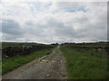
1
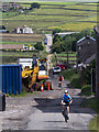
Snittle Road
View looking down Snittle Road.
Image: © Peter McDermott
Taken: 27 Jun 2015
0.01 miles
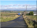
2
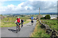
Climbing Snittle Road
Approaching Snittlegate on a tour of the Holme Valley.
Image: © michael ely
Taken: 13 Aug 2013
0.02 miles
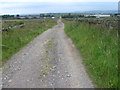
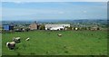
5
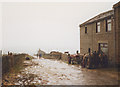
Snittlegate
A wet winter's day above Holmfirth and a muddy walk along this unsurfaced road.
Image: © Stephen Craven
Taken: 22 Nov 1992
0.07 miles
6
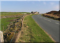
Dunford Road towards Dunford Bridge
The house is Lamb's Cote.
Image: © Andrew Tatlow
Taken: 23 Apr 2015
0.10 miles
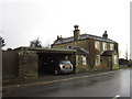
8
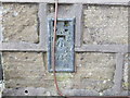
Ordnance Survey Flush Bracket 734
This can be found on the wall of the former Junction Inn (now Junction House).
For more detail see : http://www.bench-marks.org.uk/log?bm_key=719
Image: © Peter Wood
Taken: 3 Mar 2013
0.18 miles