IMAGES TAKEN NEAR TO
Greave Road, HOLMFIRTH, HD9 2DF
Introduction
This page details the photographs taken nearby to Greave Road, HD9 2DF by members of the Geograph project.
The Geograph project started in 2005 with the aim of publishing, organising and preserving representative images for every square kilometre of Great Britain, Ireland and the Isle of Man.

There are currently over 7.5m images from over14,400 individuals and you can help contribute to the project by visiting https://www.geograph.org.uk
Image Map
Images are licensed for reuse under creativecommons.org/licenses/by-sa/2.0
Notes
- Clicking on the map will re-center to the selected point.
- The higher the marker number, the further away the image location is from the centre of the postcode.
Image Listing (41 Images Found)
Images are licensed for reuse under creativecommons.org/licenses/by-sa/2.0
Image
Details
Distance
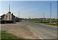
6
Greave Road towards Hade Edge
The road in the foreground is the B6106.
Image: © Andrew Tatlow
Taken: 23 Apr 2015
0.07 miles
9
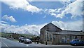
J Brindon Addy butcher and farm shop on Penistone Road
Image: © Steve Fareham
Taken: 9 May 2014
0.10 miles
10
Penistone Road towards Longley
The road is the B6106. The road to the right is Schole's Moor Road; On the left the near road is Spittle Road and the distant road is Greave Road.
Image: © Andrew Tatlow
Taken: 23 Apr 2015
0.11 miles