IMAGES TAKEN NEAR TO
Westfield Road, HOLMFIRTH, HD9 1UT
Introduction
This page details the photographs taken nearby to Westfield Road, HD9 1UT by members of the Geograph project.
The Geograph project started in 2005 with the aim of publishing, organising and preserving representative images for every square kilometre of Great Britain, Ireland and the Isle of Man.

There are currently over 7.5m images from over14,400 individuals and you can help contribute to the project by visiting https://www.geograph.org.uk
Image Map
Images are licensed for reuse under creativecommons.org/licenses/by-sa/2.0
Notes
- Clicking on the map will re-center to the selected point.
- The higher the marker number, the further away the image location is from the centre of the postcode.
Image Listing (10 Images Found)
Images are licensed for reuse under creativecommons.org/licenses/by-sa/2.0
Image
Details
Distance
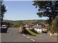
1
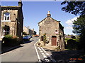
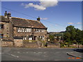
Wooldale
Along Wooldale Road toward Town End with Pell Cottage in the foreground
Image: © Stanley Walker
Taken: 25 Aug 2006
0.04 miles
2
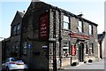
Wooldale Arms
Eponymous pub in the village of Wooldale, above New Mill
Image: © Graham Hogg
Taken: 28 Mar 2012
0.06 miles
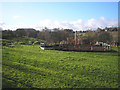
4
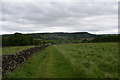
Path alongside wall.
A walk around Holmfirth.
Image: © steven ruffles
Taken: 5 Jun 2019
0.10 miles
5
Town End
Junction of Wooldale Road and Bank Lane at Town End
Image: © Stanley Walker
Taken: 25 Aug 2006
0.13 miles
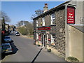
6
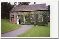
Friends' Meeting House, Wooldale
A place of worship, but not marked as a 'church or chapel' by OS.
Image: © Humphrey Bolton
Taken: 17 Sep 2000
0.13 miles
7
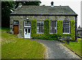
Friends' Meeting House, Wooldale
This is a revisit to the first geograph of the square, which was taken in 2000: Image There has been little change during 21 years; there are now two benches instead of the two portable seats.
Image: © Humphrey Bolton
Taken: 17 Jun 2021
0.18 miles
8
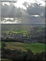
In God's Own Country
Looking down upon Wooldale from Haw Cliff
Image: © Neil Theasby
Taken: 4 Feb 2020
0.21 miles
9
Children's playground
Near Wooldale
Image: © John Illingworth
Taken: 11 Jan 2006
0.23 miles
10
Town End
Junction of Bank Lane and Cliffe Road at Town End overlooking Upperthong
Image: © Stanley Walker
Taken: 25 Aug 2006
0.24 miles