IMAGES TAKEN NEAR TO
Totties, HOLMFIRTH, HD9 1UJ
Introduction
This page details the photographs taken nearby to HD9 1UJ by members of the Geograph project.
The Geograph project started in 2005 with the aim of publishing, organising and preserving representative images for every square kilometre of Great Britain, Ireland and the Isle of Man.

There are currently over 7.5m images from over14,400 individuals and you can help contribute to the project by visiting https://www.geograph.org.uk
Image Map
Images are licensed for reuse under creativecommons.org/licenses/by-sa/2.0
Notes
- Clicking on the map will re-center to the selected point.
- The higher the marker number, the further away the image location is from the centre of the postcode.
Image Listing (24 Images Found)
Images are licensed for reuse under creativecommons.org/licenses/by-sa/2.0
Image
Details
Distance
1
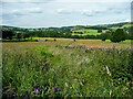
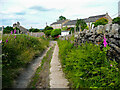
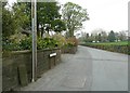
View from Totties Lane, Wooldale
This was taken from a stile, but maps old and new do not show a footpath. If there was one it would connect to a public footpath going across the view past the tree and bushes in the middle distance.
Image: © Humphrey Bolton
Taken: 29 Jun 2021
0.04 miles
2
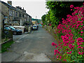
Sike Lane, Totties, Wooldale
Red Valerian (Cehtranthus ruber) on the wall to the right.
Image: © Humphrey Bolton
Taken: 29 Jun 2021
0.06 miles
3
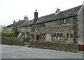
Weavers' cottages at Totties
The cottage towards the left still has all of its first-floor window lights, which gave a good light onto the loom. The cottage on the right has had some of the lights blocked, but the cills and mullions are still in place.
Image: © Humphrey Bolton
Taken: 14 Apr 2009
0.06 miles
4
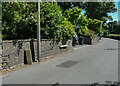
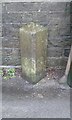
Boundary Stone, Totties Lane - St George's Road, Scholes
This is one of a series of boundary stones around the perimeter of Scholes Local Board District.
Image: © Humphrey Bolton
Taken: 1 Jul 2021
0.06 miles
5
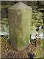
Old Boundary Marker
Parish Boundary Marker on the east side of Totties Lane, Totties. On the former boundary of Wooldale and Scholes Townships, now entirely in Holme Valley parish. Inscribed WOOLDALE and SCHOLES on adjacent faces. See also https://www.geograph.org.uk/photo/1359458.
Milestone Society National ID: YW_WOESCH02pb
Image: © D Garside
Taken: 7 Jan 2016
0.07 miles
7
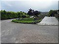
Brooklands Garden Centre Totties
Yet another garden centre in Totties. this one has wild ducks and Wallabies!
Image: © Steve Fareham
Taken: 16 Jun 2012
0.08 miles
8
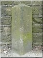
Boundary stone
Between the old townships of Wooldale and Scholes, now both part of Holmfirth civil parish.
Image: © Humphrey Bolton
Taken: 14 Apr 2009
0.10 miles
9
Location of boundary stone, St George's Road, Scholes
For a close view of the stone see Image
Image: © Humphrey Bolton
Taken: 14 Apr 2009
0.10 miles
10
Old Boundary Marker by Sike Lane, west of Totties, Holme Valley Parish
Parish Boundary Marker by the UC road, in parish of Holme Valley (Kirklees District), Totties, on Sike Lane 100m South West of hamlet.
Surveyed
Milestone Society National ID: YW_WOESCH01pb
Image: © Milestone Society
Taken: Unknown
0.11 miles