IMAGES TAKEN NEAR TO
White Wells Gardens, HOLMFIRTH, HD9 1TZ
Introduction
This page details the photographs taken nearby to White Wells Gardens, HD9 1TZ by members of the Geograph project.
The Geograph project started in 2005 with the aim of publishing, organising and preserving representative images for every square kilometre of Great Britain, Ireland and the Isle of Man.

There are currently over 7.5m images from over14,400 individuals and you can help contribute to the project by visiting https://www.geograph.org.uk
Image Map
Images are licensed for reuse under creativecommons.org/licenses/by-sa/2.0
Notes
- Clicking on the map will re-center to the selected point.
- The higher the marker number, the further away the image location is from the centre of the postcode.
Image Listing (48 Images Found)
Images are licensed for reuse under creativecommons.org/licenses/by-sa/2.0
Image
Details
Distance
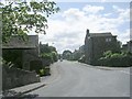
1
Grass and trees, Wickleden Gate, Scholes
It is good that three mature trees have been spared and a grass are created for them. These trees were on an old field boundary, so were probably hedgerow trees. there was a small mill dam behind them.
Image: © Humphrey Bolton
Taken: 17 Apr 2023
0.02 miles
2
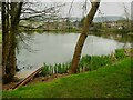
Millpond, Lee Mills, Scholes
This is now a fishing lake. I had hoped that there was a path alongside it to the bottom end of St George's Road but the gate was locked, with a Keep Out sign. The heron that I saw had no such problems.
Image: © Humphrey Bolton
Taken: 17 Apr 2023
0.07 miles
3
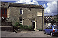
Lee Mills, Scholes
Beam engine house converted to offices. Former woollen mill.
Image: © Chris Allen
Taken: 20 May 1995
0.10 miles
4
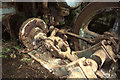
Derelict steam pump, Lee Mills, Scholes
Unknown maker and date and in a horrid hole at the back of the former boiler house. Has now been removed for private preservation.
Image: © Chris Allen
Taken: 18 Apr 1995
0.10 miles
5
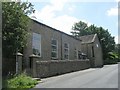
Scholes Methodist Church - Marsh Road
Image: © Betty Longbottom
Taken: 24 Jul 2010
0.10 miles
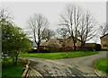
7
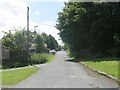
School Playing Fields - Chapelgate
Image: © Betty Longbottom
Taken: 24 Jul 2010
0.11 miles
8
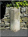
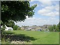
Boundary Stone, White Wells Road, Scholes
This stone is one of a series around the perimeter of Scholes Local Board. It is rather unexpected in this position within Scholes village, but there were a number of detached parts of the Wooldale township within Scholes. See also Image] for context.
Image: © Humphrey Bolton
Taken: 1 Jul 2021
0.11 miles
9
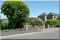
Boundary stone, White Wells Road, Scholes
See Image] for a close view of the stone and details.
Image: © Humphrey Bolton
Taken: 1 Jul 2021
0.11 miles