IMAGES TAKEN NEAR TO
Windmill View, HOLMFIRTH, HD9 1SA
Introduction
This page details the photographs taken nearby to Windmill View, HD9 1SA by members of the Geograph project.
The Geograph project started in 2005 with the aim of publishing, organising and preserving representative images for every square kilometre of Great Britain, Ireland and the Isle of Man.

There are currently over 7.5m images from over14,400 individuals and you can help contribute to the project by visiting https://www.geograph.org.uk
Image Map
Images are licensed for reuse under creativecommons.org/licenses/by-sa/2.0
Notes
- Clicking on the map will re-center to the selected point.
- The higher the marker number, the further away the image location is from the centre of the postcode.
Image Listing (8 Images Found)
Images are licensed for reuse under creativecommons.org/licenses/by-sa/2.0
Image
Details
Distance
1
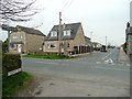
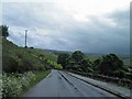
Cross Lane, Scholes
The other end of this lane has a signpost with a rare 'C' road number. At this end, however, the signpost simply shows 'Holmfirth'.
Image: © Humphrey Bolton
Taken: 14 Apr 2009
0.09 miles
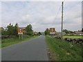
2
Junction of Ryecroft Lane to Cross lane
Image: © Steve Fareham
Taken: 16 Jun 2012
0.09 miles
3
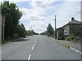
Scholes village
On Scholes Moor Road.
Image: © steven ruffles
Taken: 15 Jun 2015
0.14 miles
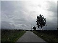
4
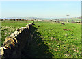
Ryecroft Lane at Ryecroft
Looking south-westward.
Image: © Peter Wood
Taken: 6 Aug 2018
0.15 miles
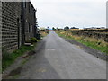
7
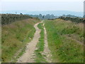
The view from the Ward Boundary stone
One wonders whether this wall follows the boundary marked by the Ward Boundary Stone adjacent to the point of view as there is about 1 mile of straight wall along this line.
Image: © Andrew Tatlow
Taken: 23 Apr 2015
0.22 miles
8
Scholes Moor Road - viewed from Chapelgate
Image: © Betty Longbottom
Taken: 24 Jul 2010
0.23 miles