IMAGES TAKEN NEAR TO
Ingdale Drive, HOLMFIRTH, HD9 1AT
Introduction
This page details the photographs taken nearby to Ingdale Drive, HD9 1AT by members of the Geograph project.
The Geograph project started in 2005 with the aim of publishing, organising and preserving representative images for every square kilometre of Great Britain, Ireland and the Isle of Man.

There are currently over 7.5m images from over14,400 individuals and you can help contribute to the project by visiting https://www.geograph.org.uk
Image Map
Images are licensed for reuse under creativecommons.org/licenses/by-sa/2.0
Notes
- Clicking on the map will re-center to the selected point.
- The higher the marker number, the further away the image location is from the centre of the postcode.
Image Listing (9 Images Found)
Images are licensed for reuse under creativecommons.org/licenses/by-sa/2.0
Image
Details
Distance
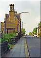
1
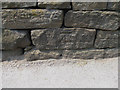
Cut benchmark on New Mill Road
This is on the wall on the west side of New Mill Road, just north of the junction with Town End Road
Image: © John Slater
Taken: 26 Jul 2012
0.07 miles

4
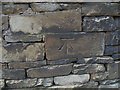
Cut benchmark on Station Road
This is on the wall on the west side of station road, opposite the south end of the almshouses (house number 78)
Image: © John Slater
Taken: 26 Jul 2012
0.17 miles
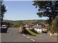
5
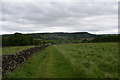
Path alongside wall.
A walk around Holmfirth.
Image: © steven ruffles
Taken: 5 Jun 2019
0.22 miles
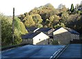
6
Holmfirth: up Station Road past site/remains of railway terminus
View northward on A635, towards Brockholes and Huddersfield: ex-L&Y terminus of branch from Brockholes, closed 3/5/65 (passengers 2/11/59). (Cf. Image]).
Image: © Ben Brooksbank
Taken: 24 Jun 1996
0.22 miles
7
Town End
Junction of Bank Lane and Cliffe Road at Town End overlooking Upperthong
Image: © Stanley Walker
Taken: 25 Aug 2006
0.23 miles
9
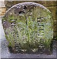
Old Boundary Marker by the A6024, Huddersfield Road
Parish Boundary Marker by the A6024, in parish of Holme Valley (Kirklees District), Bridge Mills, Holmfirth, on East side of Huddersfield Road at Bridge Mills.
Inscription reads:-
: NETHERTHO(NG) : : (H)OLMFIRTH :
Surveyed
Milestone Society National ID: YW_NTHHOL01pb
Image: © Milestone Society
Taken: Unknown
0.25 miles