IMAGES TAKEN NEAR TO
Underbank Old Road, HOLMFIRTH, HD9 1AS
Introduction
This page details the photographs taken nearby to Underbank Old Road, HD9 1AS by members of the Geograph project.
The Geograph project started in 2005 with the aim of publishing, organising and preserving representative images for every square kilometre of Great Britain, Ireland and the Isle of Man.

There are currently over 7.5m images from over14,400 individuals and you can help contribute to the project by visiting https://www.geograph.org.uk
Image Map
Images are licensed for reuse under creativecommons.org/licenses/by-sa/2.0
Notes
- Clicking on the map will re-center to the selected point.
- The higher the marker number, the further away the image location is from the centre of the postcode.
Image Listing (50 Images Found)
Images are licensed for reuse under creativecommons.org/licenses/by-sa/2.0
Image
Details
Distance
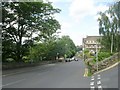
2
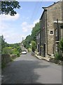
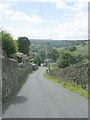
Sweep Lane - viewed from Underbank Old Road
Image: © Betty Longbottom
Taken: 24 Jul 2010
0.03 miles
3
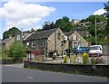
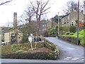
Underbank Working Men's Club - Dunford Road
Image: © Betty Longbottom
Taken: 24 Jul 2010
0.03 miles
7
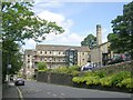
Cinder Hill
Old mill chimney by converted mill. Smart apartments below Cinder Hill.
Image: © Roger May
Taken: 2 Jan 2006
0.07 miles
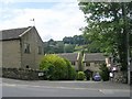
8
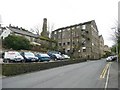
The Cragrats theatre, Dunford Road, Holmfirth
Converted from Underbank Mill. The building to the right is a new apartment block on the site of the millpond.
Image: © Humphrey Bolton
Taken: 6 Mar 2008
0.07 miles
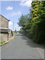
10
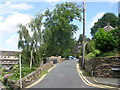
Dunford Road - viewed from Sweep Lane
Image: © Betty Longbottom
Taken: 24 Jul 2010
0.08 miles