IMAGES TAKEN NEAR TO
Well Hill Road, HD9 1AQ
Introduction
This page details the photographs taken nearby to Well Hill Road, HD9 1AQ by members of the Geograph project.
The Geograph project started in 2005 with the aim of publishing, organising and preserving representative images for every square kilometre of Great Britain, Ireland and the Isle of Man.

There are currently over 7.5m images from over14,400 individuals and you can help contribute to the project by visiting https://www.geograph.org.uk
Image Map
Images are licensed for reuse under creativecommons.org/licenses/by-sa/2.0
Notes
- Clicking on the map will re-center to the selected point.
- The higher the marker number, the further away the image location is from the centre of the postcode.
Image Listing (51 Images Found)
Images are licensed for reuse under creativecommons.org/licenses/by-sa/2.0
Image
Details
Distance
1
Old Friendship Antiques - Dunford Road
Image: © Betty Longbottom
Taken: 24 Jul 2010
0.01 miles
4
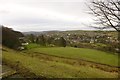
Ribble Valley, Holmfirth
Viewed from Cartworth Road: housing on the Dunford Road corridor, mill (with chimney) and Castle Hill Image visible on the horizon on the left
Image: © Richard Kay
Taken: 7 Jan 2015
0.02 miles
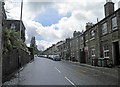
6
Swan Bank, Cartworth (Holmfirth)
Former weavers' cottages, from the days when many people operated looms in the upper floors of their houses, and identified by the long multi-light mullioned windows. The tall houses front on to Dunford Road, and the lower two storeys look to have been separate dwellings 'back-to-earth', with the weavers' windows on the upper floor. Swan Bank Mill was on the right, now converted to homes.
Image: © Humphrey Bolton
Taken: 5 Nov 2009
0.06 miles
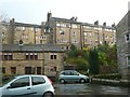
8
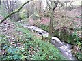
The River Ribble above Swan Bank, Cartworth (Holmfirth)
This was taken from a footpath that crosses the river by a stone footbridge. High up on the left there is a terrace of houses fronting onto Dunford Road.
Image: © Humphrey Bolton
Taken: 5 Nov 2009
0.06 miles
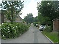
9
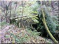
Footbridge at Swan Bank, Cartworth (Holmfirth)
This is on a footpath marked on the 1850 six-inch map and evidently important enough to warrant a stone bridge over the River Ribble.
Image: © Humphrey Bolton
Taken: 5 Nov 2009
0.06 miles