IMAGES TAKEN NEAR TO
Pilling Way, HUDDERSFIELD, HD8 9WG
Introduction
This page details the photographs taken nearby to Pilling Way, HD8 9WG by members of the Geograph project.
The Geograph project started in 2005 with the aim of publishing, organising and preserving representative images for every square kilometre of Great Britain, Ireland and the Isle of Man.

There are currently over 7.5m images from over14,400 individuals and you can help contribute to the project by visiting https://www.geograph.org.uk
Image Map
Images are licensed for reuse under creativecommons.org/licenses/by-sa/2.0
Notes
- Clicking on the map will re-center to the selected point.
- The higher the marker number, the further away the image location is from the centre of the postcode.
Image Listing (12 Images Found)
Images are licensed for reuse under creativecommons.org/licenses/by-sa/2.0
Image
Details
Distance
1
Field divided into quadrants, off Pilling Lane, Scissett
Probably with narrow strips of white plastic. No idea why.
Image: © Christine Johnstone
Taken: 1 Sep 2018
0.02 miles
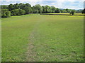
2
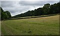
Meadows near Park Gate Dike
Walking the Emley Boundary Way.
Image: © steven ruffles
Taken: 1 Jul 2023
0.12 miles
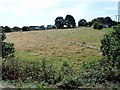
3
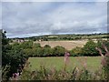
Trees lining Park Gate Dike, south of Emley Lodge
Seen from a train on the Kirklees Light Railway.
Image: © Christine Johnstone
Taken: 28 Aug 2011
0.14 miles