IMAGES TAKEN NEAR TO
Green Acres Close, HUDDERSFIELD, HD8 9RA
Introduction
This page details the photographs taken nearby to Green Acres Close, HD8 9RA by members of the Geograph project.
The Geograph project started in 2005 with the aim of publishing, organising and preserving representative images for every square kilometre of Great Britain, Ireland and the Isle of Man.

There are currently over 7.5m images from over14,400 individuals and you can help contribute to the project by visiting https://www.geograph.org.uk
Image Map
Images are licensed for reuse under creativecommons.org/licenses/by-sa/2.0
Notes
- Clicking on the map will re-center to the selected point.
- The higher the marker number, the further away the image location is from the centre of the postcode.
Image Listing (60 Images Found)
Images are licensed for reuse under creativecommons.org/licenses/by-sa/2.0
Image
Details
Distance
1
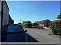
Greenacres Close coming off Warburton Road
A 1960s or 70s bungalow development near the end of a much older street on the south side of Emley.
Image: © Christine Johnstone
Taken: 3 Jul 2011
0.02 miles
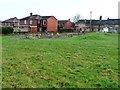
2
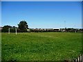
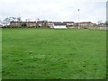
Playing field, Emley
On the west side of Warburton Road.
Image: © Christine Johnstone
Taken: 3 Jul 2011
0.03 miles
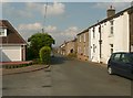
3
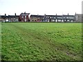
Houses on Warburton Road, Emley
Seen from the public footpath running parallel to the road.
Image: © Christine Johnstone
Taken: 30 Jan 2013
0.03 miles
4
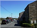
Sun and shade on Warburton Road
Old stone houses in the foreground, newer brick ones behind.
Image: © Christine Johnstone
Taken: 3 Jul 2011
0.04 miles
5
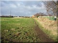
Unmapped but well-used footpath, Emley
Cutting the corner west of Warburton Road. Two public footpaths meet at an apex to the left [south-west].
Image: © Christine Johnstone
Taken: 30 Jan 2013
0.04 miles
6
Warburton, Emley
Initially there were houses only on the eastern side of Warburton, facing a field on the western side which is now partly modern houses and partly a recreation ground.
Image: © Humphrey Bolton
Taken: 28 Jul 2008
0.06 miles
7
Children's playground, Emley
West of Warburton Road.
Image: © Christine Johnstone
Taken: 30 Jan 2013
0.06 miles
8
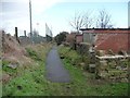
Paved public footpath, Emley
Running north-east to the main road, behind back gardens.
Image: © Christine Johnstone
Taken: 30 Jan 2013
0.07 miles
9
Cricket ground, Emley
South of the more famous football ground.
Image: © Christine Johnstone
Taken: 30 Jan 2013
0.07 miles
10
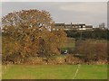
View across the Emley
Churchill Farm in the bottom of the dip, then buildings on Warburton Lane on the edge of Emley village.
Image: © Stephen Craven
Taken: 7 Dec 2016
0.08 miles