IMAGES TAKEN NEAR TO
The Close, HUDDERSFIELD, HD8 9QW
Introduction
This page details the photographs taken nearby to The Close, HD8 9QW by members of the Geograph project.
The Geograph project started in 2005 with the aim of publishing, organising and preserving representative images for every square kilometre of Great Britain, Ireland and the Isle of Man.

There are currently over 7.5m images from over14,400 individuals and you can help contribute to the project by visiting https://www.geograph.org.uk
Image Map
Images are licensed for reuse under creativecommons.org/licenses/by-sa/2.0
Notes
- Clicking on the map will re-center to the selected point.
- The higher the marker number, the further away the image location is from the centre of the postcode.
Image Listing (60 Images Found)
Images are licensed for reuse under creativecommons.org/licenses/by-sa/2.0
Image
Details
Distance
6
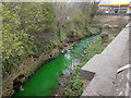
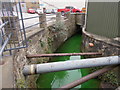
River Dearne - Wakefield Road
At this point the river was bright green in colour.
Image: © Betty Longbottom
Taken: 7 Apr 2017
0.07 miles
9
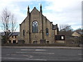
Wakefield Road Methodist Church - Wakefield Road
Image: © Betty Longbottom
Taken: 18 Feb 2017
0.08 miles
10
River Dearne - Wakefield Road
At this point the river was bright green in colour.
Image: © Betty Longbottom
Taken: 7 Apr 2017
0.09 miles