IMAGES TAKEN NEAR TO
Clayton West, HUDDERSFIELD, HD8 9QE
Introduction
This page details the photographs taken nearby to HD8 9QE by members of the Geograph project.
The Geograph project started in 2005 with the aim of publishing, organising and preserving representative images for every square kilometre of Great Britain, Ireland and the Isle of Man.

There are currently over 7.5m images from over14,400 individuals and you can help contribute to the project by visiting https://www.geograph.org.uk
Image Map
Images are licensed for reuse under creativecommons.org/licenses/by-sa/2.0
Notes
- Clicking on the map will re-center to the selected point.
- The higher the marker number, the further away the image location is from the centre of the postcode.
Image Listing (5 Images Found)
Images are licensed for reuse under creativecommons.org/licenses/by-sa/2.0
Image
Details
Distance
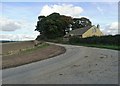
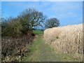
2
Path to Clayton Hall Farm
the crop in the near field is barley.Cows graze in the next field
Image: © Nigel Homer
Taken: 25 Jun 2006
0.05 miles
3
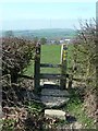
Stile on the Kirklees Way
Emley Moor TV mast is on the skyline.
Image: © Graham Hogg
Taken: 12 Mar 2012
0.06 miles
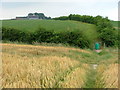
4
Footpath through the cornfield
Looking northwest towards Clayton Hall Farm
Image: © Graham Hogg
Taken: 12 Mar 2012
0.22 miles