IMAGES TAKEN NEAR TO
Paddock Close, HUDDERSFIELD, HD8 9GR
Introduction
This page details the photographs taken nearby to Paddock Close, HD8 9GR by members of the Geograph project.
The Geograph project started in 2005 with the aim of publishing, organising and preserving representative images for every square kilometre of Great Britain, Ireland and the Isle of Man.

There are currently over 7.5m images from over14,400 individuals and you can help contribute to the project by visiting https://www.geograph.org.uk
Image Map
Images are licensed for reuse under creativecommons.org/licenses/by-sa/2.0
Notes
- Clicking on the map will re-center to the selected point.
- The higher the marker number, the further away the image location is from the centre of the postcode.
Image Listing (47 Images Found)
Images are licensed for reuse under creativecommons.org/licenses/by-sa/2.0
Image
Details
Distance
1
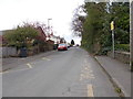
Pilling Lane - viewed from Savile Road
Image: © Betty Longbottom
Taken: 11 Apr 2017
0.08 miles
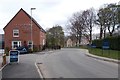
2
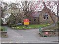
Skelmanthorpe First & Nursery School - Pilling Lane
Image: © Betty Longbottom
Taken: 11 Apr 2017
0.08 miles
3
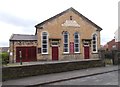
Primitive Methodist Chapel - Pilling Lane
Built 1836 - enlarged 1864
Image: © Betty Longbottom
Taken: 11 Apr 2017
0.10 miles
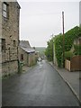
4
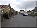
Elm Street - viewed from Savile Road
Image: © Betty Longbottom
Taken: 11 Apr 2017
0.11 miles
5
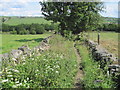
Footpath towards Blacker Farm near Skelmanthorpe
Image: © Chris Wimbush
Taken: 11 Jun 2011
0.11 miles


10
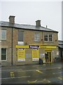
Premier Essentials - Commercial Road
Image: © Betty Longbottom
Taken: 29 May 2010
0.14 miles