IMAGES TAKEN NEAR TO
Highbridge Lane, HUDDERSFIELD, HD8 9EW
Introduction
This page details the photographs taken nearby to Highbridge Lane, HD8 9EW by members of the Geograph project.
The Geograph project started in 2005 with the aim of publishing, organising and preserving representative images for every square kilometre of Great Britain, Ireland and the Isle of Man.

There are currently over 7.5m images from over14,400 individuals and you can help contribute to the project by visiting https://www.geograph.org.uk
Image Map
Images are licensed for reuse under creativecommons.org/licenses/by-sa/2.0
Notes
- Clicking on the map will re-center to the selected point.
- The higher the marker number, the further away the image location is from the centre of the postcode.
Image Listing (28 Images Found)
Images are licensed for reuse under creativecommons.org/licenses/by-sa/2.0
Image
Details
Distance
4
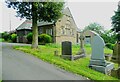
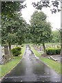
Trinity Evangelical Church in Skelmanthorpe Cemetery
This was presumably originally the mortuary chapel.
Image: © Humphrey Bolton
Taken: 26 May 2024
0.04 miles
5
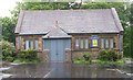
Trinity Evangelical Church - Cemetery Grounds
This building was formerly the Cemetery Chapel.
Image: © Betty Longbottom
Taken: 29 May 2010
0.04 miles
7
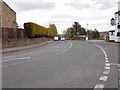
Busker Lane - viewed from near Commercial Road
Image: © Betty Longbottom
Taken: 11 Apr 2017
0.05 miles
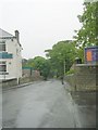
8
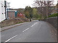
Highbridge Lane - viewed from Commercial Road
Image: © Betty Longbottom
Taken: 11 Apr 2017
0.05 miles
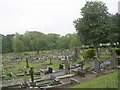
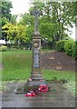
9
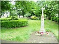
War memorial in Skelmanthorpe Cemetery
Image: © Humphrey Bolton
Taken: 26 May 2024
0.05 miles