IMAGES TAKEN NEAR TO
Denby Lane, HUDDERSFIELD, HD8 8YQ
Introduction
This page details the photographs taken nearby to Denby Lane, HD8 8YQ by members of the Geograph project.
The Geograph project started in 2005 with the aim of publishing, organising and preserving representative images for every square kilometre of Great Britain, Ireland and the Isle of Man.

There are currently over 7.5m images from over14,400 individuals and you can help contribute to the project by visiting https://www.geograph.org.uk
Image Map
Images are licensed for reuse under creativecommons.org/licenses/by-sa/2.0
Notes
- Clicking on the map will re-center to the selected point.
- The higher the marker number, the further away the image location is from the centre of the postcode.
Image Listing (5 Images Found)
Images are licensed for reuse under creativecommons.org/licenses/by-sa/2.0
Image
Details
Distance
1
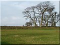
A stand of winter trees
Alongside the track to Holme.
Image: © Christine Johnstone
Taken: 6 Jan 2012
0.13 miles
2
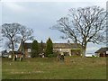
Holme, Upper Denby
Seen from Denby Lane.
Image: © Christine Johnstone
Taken: 6 Jan 2012
0.14 miles
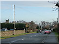
3
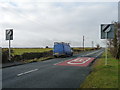
A change in the speed limit on Denby Lane
At the western edge of Upper Denby.
Image: © Christine Johnstone
Taken: 6 Jan 2012
0.15 miles
4
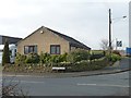
The last house in the village
Bungalow at the corner of Greenacre Lane and Denby Lane, on the western edge of Upper Denby.
Image: © Christine Johnstone
Taken: 6 Jan 2012
0.17 miles
5
Denby Lane
Looking east towards the centre of Upper Denby.
Image: © Christine Johnstone
Taken: 6 Jan 2012
0.22 miles