IMAGES TAKEN NEAR TO
Upper Putting Hill, HUDDERSFIELD, HD8 8ST
Introduction
This page details the photographs taken nearby to Upper Putting Hill, HD8 8ST by members of the Geograph project.
The Geograph project started in 2005 with the aim of publishing, organising and preserving representative images for every square kilometre of Great Britain, Ireland and the Isle of Man.

There are currently over 7.5m images from over14,400 individuals and you can help contribute to the project by visiting https://www.geograph.org.uk
Image Map
Images are licensed for reuse under creativecommons.org/licenses/by-sa/2.0
Notes
- Clicking on the map will re-center to the selected point.
- The higher the marker number, the further away the image location is from the centre of the postcode.
Image Listing (17 Images Found)
Images are licensed for reuse under creativecommons.org/licenses/by-sa/2.0
Image
Details
Distance
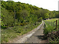
2
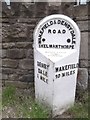
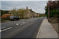
Old Milestone by the A636, Wakefield Road, Denby Dale
Metal plate attached to stone post by the A636, in parish of DENBY DALE (KIRKLEES District), Wakefield Road, North end of Denby Dale, in front of wall surrounding new housing estate at Putting Mill Walk, on East side of road. Brayshaw & Booth iron casting, erected by the County Council in the 19th century.
Inscription reads:-
: DENBY / DALE / ½ MILE : : WAKEFIELD & DENBY DALE / ROAD / SKELMANTHORPE : : WAKEFIELD / 10 MILES :
Maker:-
: BRAYSHAW & BOOTH / MAKERS / LIVERSEDGE :
Grade II listed. List Entry Number: 1185069
https://historicengland.org.uk/listing/the-list/list-entry/1185069
Milestone Society National ID: YW_WKDD10.
Image: © C Minto
Taken: 1 Apr 2002
0.05 miles
3
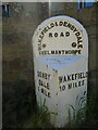
Old milestone
One of the five remaining West Riding CC milestones with a protruding attachment still to be seen on this route, A636, from Wakefield to Denby Dale. It is at the northeastern end of Denby Dale, although apparently this area was in Skelmanthorpe parish. It is close to the entrance to Putting Mill Walk. Grade II listed 1185069.
Image: © Chris Minto
Taken: 10 Jul 2022
0.06 miles
4
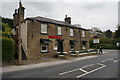
Aagrah restaurant on Wakefield Road, Denby Dale
Image: © Ian S
Taken: 8 May 2015
0.10 miles

6
Footpath on track to Lower Putting Mill, Denby Dale
Lower Putting Mill appears on the 1893 1:2500 map to already have been converted to houses.
Image: © Humphrey Bolton
Taken: 14 May 2020
0.15 miles
7
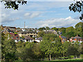
Housing on Thorpes Avenue, Denby Dale
Viewed from White Close Lane. Emley Moor TV mast is visible on the horizon.
Image: © Stephen Craven
Taken: 17 Oct 2019
0.15 miles
9
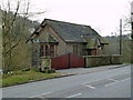
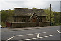
Small house on the A636
Possibly formerly a lodge to the nearby Bagden Hall?
Image: © Graham Hogg
Taken: 12 Mar 2012
0.17 miles
10
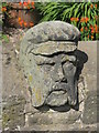
Detail on a wall
Detail on a wall spotted near Scissett, West Yorkshire.
Image: © Dave Pickersgill
Taken: 12 Aug 2010
0.19 miles