IMAGES TAKEN NEAR TO
The Knowle, HUDDERSFIELD, HD8 8EA
Introduction
This page details the photographs taken nearby to The Knowle, HD8 8EA by members of the Geograph project.
The Geograph project started in 2005 with the aim of publishing, organising and preserving representative images for every square kilometre of Great Britain, Ireland and the Isle of Man.

There are currently over 7.5m images from over14,400 individuals and you can help contribute to the project by visiting https://www.geograph.org.uk
Image Map
Images are licensed for reuse under creativecommons.org/licenses/by-sa/2.0
Notes
- Clicking on the map will re-center to the selected point.
- The higher the marker number, the further away the image location is from the centre of the postcode.
Image Listing (50 Images Found)
Images are licensed for reuse under creativecommons.org/licenses/by-sa/2.0
Image
Details
Distance
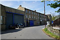
5
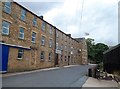
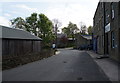
Victoria Mills, Shepley
Former textile mill which is now home to Shepley Spring bottled water company as well as other businesses.
Image: © Jonathan Clitheroe
Taken: 29 Aug 2015
0.09 miles
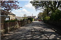
9
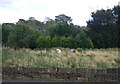
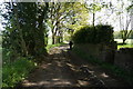
Grazing and woodland
Off Abbey Road North (A629).
Image: © JThomas
Taken: 3 Oct 2014
0.10 miles