IMAGES TAKEN NEAR TO
Turnshaw Road, HUDDERSFIELD, HD8 0TL
Introduction
This page details the photographs taken nearby to Turnshaw Road, HD8 0TL by members of the Geograph project.
The Geograph project started in 2005 with the aim of publishing, organising and preserving representative images for every square kilometre of Great Britain, Ireland and the Isle of Man.

There are currently over 7.5m images from over14,400 individuals and you can help contribute to the project by visiting https://www.geograph.org.uk
Image Map
Images are licensed for reuse under creativecommons.org/licenses/by-sa/2.0
Notes
- Clicking on the map will re-center to the selected point.
- The higher the marker number, the further away the image location is from the centre of the postcode.
Image Listing (18 Images Found)
Images are licensed for reuse under creativecommons.org/licenses/by-sa/2.0
Image
Details
Distance
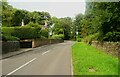
1
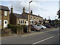
The Junction Inn, Paddock Road, Kirkburton
At a junction of minor roads that were perhaps more important in the past.
Image: © Humphrey Bolton
Taken: 17 Apr 2008
0.04 miles
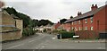
2
Paddock Road, Kirkburton
The road has gradually become built up over the last two centuries.
Image: © Humphrey Bolton
Taken: 17 Apr 2008
0.04 miles
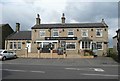
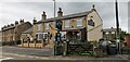
4
The Junction Inn, Kirkburton
On Paddock Road.
Image: © JThomas
Taken: 12 Oct 2019
0.06 miles
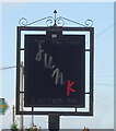
7
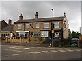
The Junction Inn
At the junction of Paddock Road, Laneside and Turnshaw Road. Also know locally as 'The Junk'
Image: © Graham Hogg
Taken: 1 Oct 2020
0.07 miles
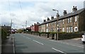
8
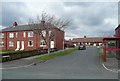
The Crescent, Kirkburton
A housing estate off Paddock Road.
Image: © Humphrey Bolton
Taken: 17 Apr 2008
0.09 miles