IMAGES TAKEN NEAR TO
/Low Moor, HUDDERSFIELD, HD8 0NB
Introduction
This page details the photographs taken nearby to /Low Moor, HD8 0NB by members of the Geograph project.
The Geograph project started in 2005 with the aim of publishing, organising and preserving representative images for every square kilometre of Great Britain, Ireland and the Isle of Man.

There are currently over 7.5m images from over14,400 individuals and you can help contribute to the project by visiting https://www.geograph.org.uk
Image Map
Images are licensed for reuse under creativecommons.org/licenses/by-sa/2.0
Notes
- Clicking on the map will re-center to the selected point.
- The higher the marker number, the further away the image location is from the centre of the postcode.
Image Listing (15 Images Found)
Images are licensed for reuse under creativecommons.org/licenses/by-sa/2.0
Image
Details
Distance
1
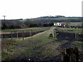
View along path from Town End Lane
towards Low Moor
Image: © Nigel Homer
Taken: 14 Feb 2006
0.07 miles
2
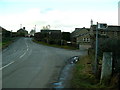
Pinfold and Town End Lanes
A quiete(ish) lanes near Lepton
Image: © Nigel Homer
Taken: 14 Feb 2006
0.15 miles
3
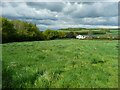
Kirkburton FP 82/10 off Pinfold Lane, Lepton
This is an update to Image The fences each side of the path have been removed and the field is covered with long grass, which will probably be cut for hay.
Image: © Humphrey Bolton
Taken: 17 May 2021
0.16 miles
4
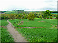
Footpath from Botany Lane to Rods Beck, Lepton
This is Footpath KIR/30/10. It is a broad path, probably due to people trying to avoid sticky mud on the surface. The field is enormous, due to the removal of the hedgerows shown on old maps. Fortunately the trees have been retained.
Image: © Humphrey Bolton
Taken: 16 May 2021
0.20 miles
5
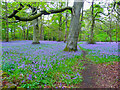
Bluebells in Far Walk, Lepton
If you wander a little way off the public path you can get a view of this wonderful carpet of bluebells.
Image: © Humphrey Bolton
Taken: 16 May 2021
0.22 miles
6

Old Boundary Marker by footpath in Kirkburton parish
Estate Boundary Marker by the footpath, in parish of Kirkburton (Kirklees District), on wooded track, by gatepost.
Surveyed
Milestone Society National ID: YW_KIR02em
Image: © Milestone Society
Taken: Unknown
0.23 miles
7
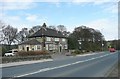
The White Horse, Wakefield Road, Lepton
A main road pub, on the edge of the village.
Image: © Humphrey Bolton
Taken: 10 Apr 2008
0.23 miles
8
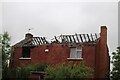
Derelict building
Been derelict for a few years now.
Image: © Terry
Taken: 30 May 2023
0.23 miles
9
The Willows, 297 Wakefield Road
This new house appears to be close to completion.
Image: © Christine Johnstone
Taken: 12 Jun 2010
0.23 miles
10
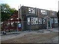
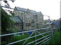
The former White Horse pub
Presumably the planners said that the frontage had to be retained.
Image: © Christine Johnstone
Taken: 12 Jun 2010
0.23 miles