IMAGES TAKEN NEAR TO
HD7 7HP
Introduction
This page details the photographs taken nearby to HD7 7HP by members of the Geograph project.
The Geograph project started in 2005 with the aim of publishing, organising and preserving representative images for every square kilometre of Great Britain, Ireland and the Isle of Man.

There are currently over 7.5m images from over14,400 individuals and you can help contribute to the project by visiting https://www.geograph.org.uk
Image Map
Images are licensed for reuse under creativecommons.org/licenses/by-sa/2.0
Notes
- Clicking on the map will re-center to the selected point.
- The higher the marker number, the further away the image location is from the centre of the postcode.
Image Listing (59 Images Found)
Images are licensed for reuse under creativecommons.org/licenses/by-sa/2.0
Image
Details
Distance
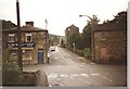
2
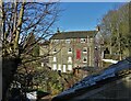
East Street - viewed from Chapel Bank
Image: © Betty Longbottom
Taken: 24 Jul 2010
0.01 miles
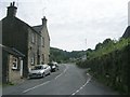
3
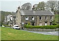
Houses, East Street, Jackson Bridge
At the top of the street, next to Sheffield Road. The grass in the foreground is someone's lawn.
Image: © Humphrey Bolton
Taken: 14 Apr 2009
0.01 miles
4
East Street - viewed from Chapel Bank
Image: © Betty Longbottom
Taken: 24 Jul 2010
0.02 miles
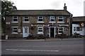
5
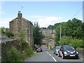
View of "The Red Lion Inn", Jackson Bridge
Image: © Neil Theasby
Taken: 22 Jan 2021
0.02 miles
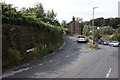
6
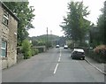
East Street - viewed from Bank Street
Image: © Betty Longbottom
Taken: 24 Jul 2010
0.02 miles
7

Chapel Bank - viewed from East Street
Image: © Betty Longbottom
Taken: 24 Jul 2010
0.02 miles
8

Jackson Bridge Working Men's Club - Chapel Bank
Image: © Betty Longbottom
Taken: 24 Jul 2010
0.02 miles