IMAGES TAKEN NEAR TO
/Lane Head/Well Lane, HUDDERSFIELD, HD7 6NW
Introduction
This page details the photographs taken nearby to /Lane Head/Well Lane, HD7 6NW by members of the Geograph project.
The Geograph project started in 2005 with the aim of publishing, organising and preserving representative images for every square kilometre of Great Britain, Ireland and the Isle of Man.

There are currently over 7.5m images from over14,400 individuals and you can help contribute to the project by visiting https://www.geograph.org.uk
Image Map (Loading...)


Getting Data...Please wait
Leaflet Map data © OpenStreetMap
Images are licensed for reuse under creativecommons.org/licenses/by-sa/2.0
Notes
- Clicking on the map will re-center to the selected point.
- The higher the marker number, the further away the image location is from the centre of the postcode.
Image Listing (60 Images Found)
Images are licensed for reuse under creativecommons.org/licenses/by-sa/2.0
Image
Details
Distance
1
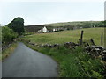
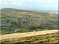
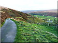
Springhall Farm, below Binn Edge
From the west, on the road that leads into Marsden.
Image: © Christine Johnstone
Taken: 10 Jun 2020
0.01 miles
5
From Binn Edge
The view across to Pule Hill
Image: © Nigel Homer
Taken: 1 Jan 2005
0.08 miles
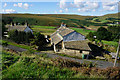
6
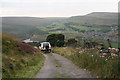
Bowling down towards Marsden
Track seems named Well Lane Head.
Image: © Chris
Taken: 12 Sep 2014
0.09 miles
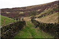
7
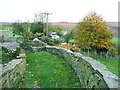
The Colne Valley Circular Walk at Owlers End
The path goes through a stile on the right, just before the gate into the garden. The public footpath sign is presumably to make sure that walkers go through the stile and not the gate.
Image: © Humphrey Bolton
Taken: 26 Oct 2013
0.09 miles
9
The Colne Valley Circular Walk
The route comes down the tarmac driveway for Acre Head, and then goes down the old track to the right. Alternatively if you don't like wet grass you can continue down the driveway, which is also a public footpath, to Binn Lane.
Image: © Humphrey Bolton
Taken: 28 Oct 2013
0.10 miles
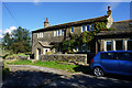
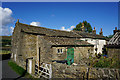
10
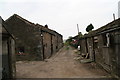
Traditional farm buildings on Binn Lane
Named on the map as Peters Farm.
Image: © Chris
Taken: 12 Sep 2014
0.11 miles