IMAGES TAKEN NEAR TO
Blake Lee Lane, HUDDERSFIELD, HD7 6NR
Introduction
This page details the photographs taken nearby to Blake Lee Lane, HD7 6NR by members of the Geograph project.
The Geograph project started in 2005 with the aim of publishing, organising and preserving representative images for every square kilometre of Great Britain, Ireland and the Isle of Man.

There are currently over 7.5m images from over14,400 individuals and you can help contribute to the project by visiting https://www.geograph.org.uk
Image Map
Images are licensed for reuse under creativecommons.org/licenses/by-sa/2.0
Notes
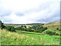
- Clicking on the map will re-center to the selected point.
- The higher the marker number, the further away the image location is from the centre of the postcode.
Image Listing (91 Images Found)
Images are licensed for reuse under creativecommons.org/licenses/by-sa/2.0
Image
Details
Distance
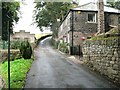
1

Wall enclosed Blake Lea Lane near Hey Green
Looking north-westward.
Image: © Peter Wood
Taken: 6 Oct 2021
0.04 miles
3
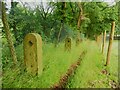
Stone fence posts alongside Footpath 194/2
I think this is the longest set of stone fence posts that I have ever seen, and perhaps unusual in having small circular holes, presumably for iron rods, in addition to the usual square holes for wooden beams.
Image: © Humphrey Bolton
Taken: 19 Jul 2023
0.05 miles
5
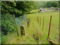
Stone fence posts alongside Footpath 194/2
These have a diamond shaped hole for a square beam of wood, but also small circular holes for iron roads, and there are the remains of iron brackets on the top.
Image: © Humphrey Bolton
Taken: 19 Jul 2023
0.07 miles
6
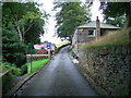
Blake Lee Lane
Halfway up the lane and the path going off to the left leads you to the packhorse bridge at Blake Lee
Image: © Stanley Walker
Taken: 3 Sep 2008
0.07 miles
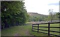
7
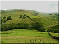
Blake Lea Lane, Marsden
Seen from the A62 road, near to Dark Lane (bottom left). The lane gives access to farms on the hillside.
Image: © Humphrey Bolton
Taken: 8 May 2008
0.07 miles
8
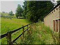
Footpath 194/2 passing Hey Green, Marsden
This path is evidently not heavily used, as it is becoming overgrown in places, especially by nettles. At the bottom, after leaving Blake Lee Lane, pass through an iron gate and then don't approach the next gate, which is a private one and locked, but keep to the right into a sunken path.
Image: © Humphrey Bolton
Taken: 19 Jul 2023
0.07 miles
9
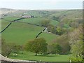
View from where Blake Lee Lane meets Park Lane, Marsden
The road name changes at a sharp bend according to the 1850 six-inch map. I am surprised that no-one has taken and submitted this view before. At the bottom of the slope you can see Close Gate packhorse bridge, then Dark Lane, which was Pule Lane in 1850, climbs up to the A62. Above this is the quarry at Little Nab End, which I have never visited. Pule Hill is in the distance.
Image: © Humphrey Bolton
Taken: 19 Jul 2023
0.07 miles
10
The Standedge Trail leaves the tarmac road
Path leaves off to the left towards Close Gate bridge
Image: © Raymond Knapman
Taken: 2 Sep 2009
0.07 miles