IMAGES TAKEN NEAR TO
Bank Bottom Cottages, HUDDERSFIELD, HD7 6HS
Introduction
This page details the photographs taken nearby to Bank Bottom Cottages, HD7 6HS by members of the Geograph project.
The Geograph project started in 2005 with the aim of publishing, organising and preserving representative images for every square kilometre of Great Britain, Ireland and the Isle of Man.

There are currently over 7.5m images from over14,400 individuals and you can help contribute to the project by visiting https://www.geograph.org.uk
Image Map
Images are licensed for reuse under creativecommons.org/licenses/by-sa/2.0
Notes
- Clicking on the map will re-center to the selected point.
- The higher the marker number, the further away the image location is from the centre of the postcode.
Image Listing (119 Images Found)
Images are licensed for reuse under creativecommons.org/licenses/by-sa/2.0
Image
Details
Distance
1
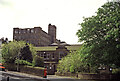
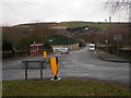
Bank Bottom Mill, Marsden
According to Alexander Kapp - It was built in 1801, and eventually replaced Top Bank Mill, which was demolished in 1891. It closed down in 2003.
This is the main entrance to the site. This view is from near the beginning of Binn Road at its junction with Carrs Road.
Image: © Chris Allen
Taken: 10 May 1992
0.01 miles

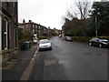
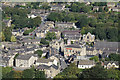
3

Former co-op branch, Binn Road, Marsden
This would have been opened to serve the southern part of Marsden, which was developed to house the workforce of Bank Bottom Mills, part of which can be seen in the background.
Image: © Humphrey Bolton
Taken: 19 Jun 2008
0.02 miles
5
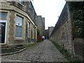
Kirklees Way heading south out of Marsden
Over the setts and through a former textile mill.
Image: © Christine Johnstone
Taken: 10 Jun 2020
0.03 miles
6
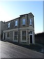
Marsden Equitable Industrial Society building
Marsden Equitable Industrial Society was established in 1859 in premises in Cockslip and by 1862 had expanded to premises in Ready Carr before moving again to a block of buildings situated in the Market Place. It continued to flourish, increasing its range during the rest of the nineteenth century and continued successfully during the first part of the twentieth century. In 1972 it transferred its engagements to Co-operative Retail Services
Image: © Neil Theasby
Taken: 7 Nov 2013
0.03 miles
9

Bank Bottom Mill
Viewed from Mount Road. It was built in 1801, and eventually replaced Top Bank Mill, which was demolished in 1891. It closed down in 2003.
Image: © Alexander P Kapp
Taken: 20 Aug 2009
0.05 miles
