IMAGES TAKEN NEAR TO
Mount Road, HUDDERSFIELD, HD7 6HH
Introduction
This page details the photographs taken nearby to Mount Road, HD7 6HH by members of the Geograph project.
The Geograph project started in 2005 with the aim of publishing, organising and preserving representative images for every square kilometre of Great Britain, Ireland and the Isle of Man.

There are currently over 7.5m images from over14,400 individuals and you can help contribute to the project by visiting https://www.geograph.org.uk
Image Map (Loading...)


Getting Data...Please wait
Leaflet Map data © OpenStreetMap
Images are licensed for reuse under creativecommons.org/licenses/by-sa/2.0
Notes
- Clicking on the map will re-center to the selected point.
- The higher the marker number, the further away the image location is from the centre of the postcode.
Image Listing (62 Images Found)
Images are licensed for reuse under creativecommons.org/licenses/by-sa/2.0
Image
Details
Distance
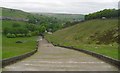
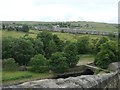
1
Valley hillside and view to Marsden
The hillside is just below the dam of Butterley Reservoir near Netherley. The large buildings are Bank Bottom Mills in the next square north.
Image: © Andrew Hill
Taken: 11 Jul 2013
0.04 miles
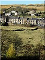
4
Houses on Mount Road, Marsden
Looking across the Wessenden valley, from the steps up the side of Butterley reservoir dam.
Image: © Christine Johnstone
Taken: 10 Jun 2020
0.06 miles
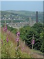
5
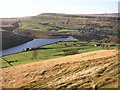
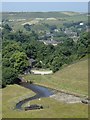
View over Butterley Reservoir, Marsden
This is taken from the path alongside the high-level water conduit below Binn Moor. See 'Wessenden Valley' photo for notes on the reservoirs. On the opposite hillside houses mark the lines of Mount Road and Old Mount Road (higher up) and then a long sloping line, which is a low ridge concealing a shallow valley. The Summit is Pule Hill.
Image: © Humphrey Bolton
Taken: 13 Nov 2005
0.07 miles
6
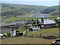
Overlooking Netherley and the Butterley Reservoir
View to houses on and around Mount Road from Old Mount Road.
Image: © Andrew Hill
Taken: 11 Jul 2013
0.07 miles
7
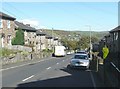
Mount Road, Marsden
Old Mount Road was turnpiked in the 18C to allow transport by coach and cart, but it was steep and narrow. This second turnpike road was constructed in the early 19C, but it was evidently still considered to be too steep and it was later superseded as a main road by the present A62. It remained as a convenient road to build houses along.
Image: © Humphrey Bolton
Taken: 7 Oct 2010
0.08 miles
8
Footpaths below Butterley Reservoir
Looking S from the footpaths at SE 047 108.
Image: © Mark Anderson
Taken: 18 Sep 2005
0.09 miles
9
Valley view from the Butterley Reservoir dam
Parts of Marsden can be seen amongst the valley woodland beyond.
Image: © Andrew Hill
Taken: 11 Jul 2013
0.10 miles