IMAGES TAKEN NEAR TO
Spring Head Lane, HD7 6ED
Introduction
This page details the photographs taken nearby to Spring Head Lane, HD7 6ED by members of the Geograph project.
The Geograph project started in 2005 with the aim of publishing, organising and preserving representative images for every square kilometre of Great Britain, Ireland and the Isle of Man.

There are currently over 7.5m images from over14,400 individuals and you can help contribute to the project by visiting https://www.geograph.org.uk
Image Map
Images are licensed for reuse under creativecommons.org/licenses/by-sa/2.0
Notes
- Clicking on the map will re-center to the selected point.
- The higher the marker number, the further away the image location is from the centre of the postcode.
Image Listing (145 Images Found)
Images are licensed for reuse under creativecommons.org/licenses/by-sa/2.0
Image
Details
Distance
1
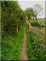
The western end of the footpath section of Spring Head Lane, Marsden
Image: © Humphrey Bolton
Taken: 5 May 2023
0.01 miles

3
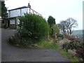
Spring Head Lane at Ingle Nook, Marsden
This is the end of the tarmac. Here the lane forks. A public footpath goes left up to Heck Hill, and another, the continuation of Spring Head Lane, goes straight forward along the contour to Dirker, Mount Pleasant and Old House. Someone has spent money on a pair of steel gateposts.
Image: © Humphrey Bolton
Taken: 5 Jan 2013
0.02 miles

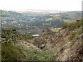

7
Spring Head Lane, Marsden
This is a very steep hill.
Image: © Humphrey Bolton
Taken: 5 May 2023
0.06 miles


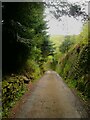
10
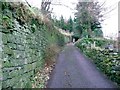
Spring Head Lane, Marsden
A narrow lane now leading to only one house, but originally part of a network of lanes on the hillside. These are now public footpaths. Making this lane must have been an immense task, as it was cut into the slope, probably into rock, and a long, high retaining wall built.
Image: © Humphrey Bolton
Taken: 5 Jan 2013
0.08 miles