IMAGES TAKEN NEAR TO
Towngate, HUDDERSFIELD, HD7 6DD
Introduction
This page details the photographs taken nearby to Towngate, HD7 6DD by members of the Geograph project.
The Geograph project started in 2005 with the aim of publishing, organising and preserving representative images for every square kilometre of Great Britain, Ireland and the Isle of Man.

There are currently over 7.5m images from over14,400 individuals and you can help contribute to the project by visiting https://www.geograph.org.uk
Image Map
Images are licensed for reuse under creativecommons.org/licenses/by-sa/2.0
Notes
- Clicking on the map will re-center to the selected point.
- The higher the marker number, the further away the image location is from the centre of the postcode.
Image Listing (283 Images Found)
Images are licensed for reuse under creativecommons.org/licenses/by-sa/2.0
Image
Details
Distance
1
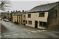
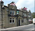
Houses, Town Gate, Marsden
The nearest house was originally two houses, built at separate times in the 18C and listed, Garde II. This street was the old way into the town from the west.
Image: © Humphrey Bolton
Taken: 12 Apr 2023
0.00 miles
2
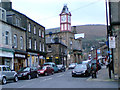
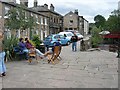
Peel St, Marsden
View from outside the Riverhead Brewery Tap looking south east along Peel Street toward the Mechanics Institute.
Image: © Tim Marchant
Taken: 15 Nov 2006
0.01 miles
4
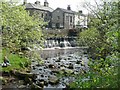
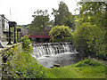
Weir off Station Road, Marsden
A beauty spot in the town centre.
Image: © Humphrey Bolton
Taken: 8 May 2008
0.01 miles
5
The Swan, Station Road, Marsden
With a glimpse of the Methodist Chapel on the right.
Image: © Humphrey Bolton
Taken: 8 May 2008
0.01 miles
6
Marsden Riverside
View from Peel St down Argyle Street outside the Riverhead Brewery Tap
Image: © Tim Marchant
Taken: 12 Aug 2006
0.01 miles
7
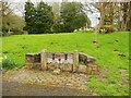
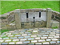
The stocks, Town Gate, Marsden
The old churchyard is behind the stocks. The gravestones seem to have been removed, leaving one chest tomb.
Image: © Humphrey Bolton
Taken: 12 Apr 2023
0.01 miles
8
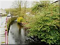
Wessenden Brook alongside Weir Side, Marsden
The tree appears to be a Cotoneaster, probably C. 'Cornubia', which can grow to 6m high with a spread of 6m.
Image: © Humphrey Bolton
Taken: 12 Apr 2023
0.01 miles
9
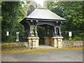
St Bartholomew's Parish Church, Marsden, Lych Gate
Image: © Alexander P Kapp
Taken: 20 Aug 2009
0.03 miles
10
Weir and Footbridge, River Colne, Marsden
Image: © David Dixon
Taken: 16 Jun 2011
0.03 miles