IMAGES TAKEN NEAR TO
Market Walk, HUDDERSFIELD, HD7 6BX
Introduction
This page details the photographs taken nearby to Market Walk, HD7 6BX by members of the Geograph project.
The Geograph project started in 2005 with the aim of publishing, organising and preserving representative images for every square kilometre of Great Britain, Ireland and the Isle of Man.

There are currently over 7.5m images from over14,400 individuals and you can help contribute to the project by visiting https://www.geograph.org.uk
Image Map (Loading...)


Getting Data...Please wait
Leaflet Map data © OpenStreetMap
Images are licensed for reuse under creativecommons.org/licenses/by-sa/2.0
Notes
- Clicking on the map will re-center to the selected point.
- The higher the marker number, the further away the image location is from the centre of the postcode.
Image Listing (289 Images Found)
Images are licensed for reuse under creativecommons.org/licenses/by-sa/2.0
Image
Details
Distance
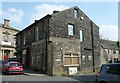
1
Peel Street, Marsden
The building on the left is dated 1896 and inscribed 'Marsden Equitable Industrial Society Ltd'. It is good that it is still a Co-op shop as so many of the old Co-op shops have been converted to other uses.
Image: © Humphrey Bolton
Taken: 13 Nov 2005
0.02 miles
2
Oliver Lane, Marsden
Street names carved in stone.
Image: © Humphrey Bolton
Taken: 8 May 2008
0.02 miles
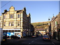
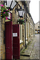
3
Post Office, Peel Street, Marsden
One of a row of shops in the town centre.
Image: © Humphrey Bolton
Taken: 8 May 2008
0.02 miles
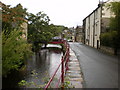
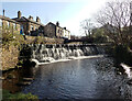
6
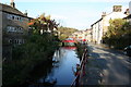
Weir Side, Marsden
The weir in question is just beyond the red bridge - the same bridge is also visible in Image
Image: © Dave Dunford
Taken: 20 Oct 2007
0.02 miles
7
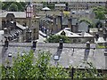
Marsden rooftops
The prominent clock tower is the Mechanics Institute.
Image: © Steve Fareham
Taken: 25 Aug 2015
0.03 miles
8
Argyle Street, Marsden
On the immediate left is a doorway into the Riverhead Brewery Tap and beyond that a fine row of terraced cottages and a traditional cobbled street surface. This is part of the Marsden Conservation Area.
Image: © Stephen McKay
Taken: 9 Jul 2016
0.03 miles
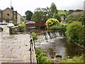
9
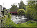
Weir and Footbridge, River Colne, Marsden
Image: © David Dixon
Taken: 16 Jun 2011
0.03 miles