IMAGES TAKEN NEAR TO
Crimea Lane, HUDDERSFIELD, HD7 5WD
Introduction
This page details the photographs taken nearby to Crimea Lane, HD7 5WD by members of the Geograph project.
The Geograph project started in 2005 with the aim of publishing, organising and preserving representative images for every square kilometre of Great Britain, Ireland and the Isle of Man.

There are currently over 7.5m images from over14,400 individuals and you can help contribute to the project by visiting https://www.geograph.org.uk
Image Map
Images are licensed for reuse under creativecommons.org/licenses/by-sa/2.0
Notes
- Clicking on the map will re-center to the selected point.
- The higher the marker number, the further away the image location is from the centre of the postcode.
Image Listing (24 Images Found)
Images are licensed for reuse under creativecommons.org/licenses/by-sa/2.0
Image
Details
Distance
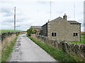
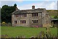
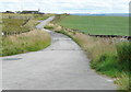
3
Crimea Lane, Slaithwaite
This is the western end. The tarmac probably only goes as far as the house in the distance.
Image: © Humphrey Bolton
Taken: 27 Mar 2008
0.05 miles
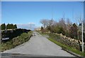
6
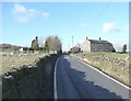
Pole Gate, Slaithwaite
Climbing up to the ridge at Pole Moor. Part of Worts Hill on the skyline at the left, and a house with weavers' windows on the right.
Image: © Humphrey Bolton
Taken: 27 Mar 2008
0.06 miles
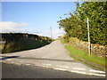

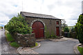
10
Driveway to the radio station and Moorside Edge
Seen from the junction with Crimea Lane.
Image: © Humphrey Bolton
Taken: 15 Aug 2013
0.10 miles