IMAGES TAKEN NEAR TO
Upper Rotcher, HUDDERSFIELD, HD7 5UE
Introduction
This page details the photographs taken nearby to Upper Rotcher, HD7 5UE by members of the Geograph project.
The Geograph project started in 2005 with the aim of publishing, organising and preserving representative images for every square kilometre of Great Britain, Ireland and the Isle of Man.

There are currently over 7.5m images from over14,400 individuals and you can help contribute to the project by visiting https://www.geograph.org.uk
Image Map
Images are licensed for reuse under creativecommons.org/licenses/by-sa/2.0
Notes
- Clicking on the map will re-center to the selected point.
- The higher the marker number, the further away the image location is from the centre of the postcode.
Image Listing (41 Images Found)
Images are licensed for reuse under creativecommons.org/licenses/by-sa/2.0
Image
Details
Distance
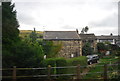
2
Blakestones, Slaithwaite
The hamlet of Blakestones sits alongside the trans-Pennine rail link.
Image: © Pamela Norrington
Taken: 22 Dec 2009
0.06 miles
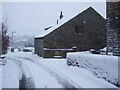
3
Footpath, Stones Laithe
Looking down footpath towards Stones Laithe, near Slaithwaite.
Image: © Samantha Waddington
Taken: 3 Sep 2011
0.08 miles
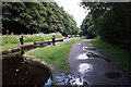
5
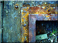
Old Lock Gate detail
Part of an old lock gate by the towpath of the Huddersfield Narrow Canal.
Taken during the hot Summer of 2006. By Winter the colours had faded to almost a monochrome, in keeping with the surrounding woodland.
Image: © Howard Selina
Taken: Unknown
0.11 miles
6
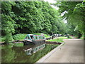
Huddersfield Narrow Canal near Slaithwaite
A narrowboat negotiating a lock on the Huddersfield Narrow Canal, near Slaithwaite in West Yorkshire.
Image: © Malc McDonald
Taken: 13 Jun 2021
0.12 miles
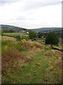
7
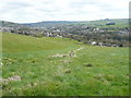
View along broken wall towards Rotcher, Slaithwaite
This is the view from Image
Image: © Humphrey Bolton
Taken: 28 Apr 2016
0.15 miles
8
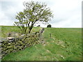
Footpath from Owlers Wood to Lower Holme, Slaithwaite
This path is not used enough to be visible.
Image: © Humphrey Bolton
Taken: 28 Apr 2016
0.16 miles
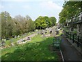
9

Slaithwaite Cemetery, Manchester Road, Lingards
The north-eastern part of the cemetery, with graves cared for and decorated with floral tributes. The canal is below the trees on the left.
Image: © Humphrey Bolton
Taken: 8 May 2008
0.16 miles
10
Slaithwaite Cemetery, Manchester Road, Lingards
There was a chapel on the right, which has now been demolished.
Image: © Humphrey Bolton
Taken: 8 May 2008
0.16 miles