IMAGES TAKEN NEAR TO
Manchester Road, HUDDERSFIELD, HD7 5RT
Introduction
This page details the photographs taken nearby to Manchester Road, HD7 5RT by members of the Geograph project.
The Geograph project started in 2005 with the aim of publishing, organising and preserving representative images for every square kilometre of Great Britain, Ireland and the Isle of Man.

There are currently over 7.5m images from over14,400 individuals and you can help contribute to the project by visiting https://www.geograph.org.uk
Image Map
Images are licensed for reuse under creativecommons.org/licenses/by-sa/2.0
Notes
- Clicking on the map will re-center to the selected point.
- The higher the marker number, the further away the image location is from the centre of the postcode.
Image Listing (83 Images Found)
Images are licensed for reuse under creativecommons.org/licenses/by-sa/2.0
Image
Details
Distance
1

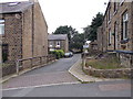
Bargate joins Manchester Road in Linthwaite
Image: © Raymond Knapman
Taken: 11 Apr 2014
0.04 miles
2
Hoyle Ing - viewed from Hoyle Beck Close
Image: © Betty Longbottom
Taken: 2 Aug 2016
0.06 miles
3

Titanic Mill, Linthwaite
This is a centre facade view of Titanic Mills built in 1912 and now redeveloped into apartments. The red brick chimney in the centre of the image belongs to another mill that is situated on A62 Manchester Road. Above is the Lane Top area of Linthwaite with Crosland Moor beyond. Photographed from a hillside path connecting Lowestwood Lane and Radcliffe Road at Upper Wellhouse.
Image: © Bobby Clegg
Taken: 30 Aug 2012
0.07 miles
4
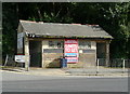
Disused public conveniences, Manchester Road
They appear to be 'to let' as part of Linthwaite Business Centre!
Image: © Humphrey Bolton
Taken: 15 Aug 2013
0.07 miles
5
Old Toll House by Manchester Road, Linthwaite
Holly Well by the A62, in parish of Slaithwaite and Marsden (Kirklees District), Florist Shop by Bargate, Manchester Road, Linthwaite, junction with Coldwell Street (Hole Ing Bottom on old maps) and Bargate.
See also: Image
Surveyed
Milestone Society National ID: YW.HUD01
Image: © Milestone Society
Taken: Unknown
0.08 miles
6
Old Toll House by Manchester Road, Linthwaite
Holly Well by the A62, in parish of Slaithwaite and Marsden (Kirklees District), Florist Shop by Bargate, Manchester Road, Linthwaite, junction with Coldwell Street (Hole Ing Bottom on old maps) and Bargate.
See also: Image
To be surveyed
Milestone Society National ID: YW.HUD01
Image: © Milestone Society
Taken: Unknown
0.08 miles

9
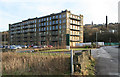
Titanic Mill
Now converted to apartments. It's nice that the overall shape has been retained but I don't like balconies on mills. The chimney is on a dyeworks the other side of the A62. I'm on Low Westwood Lane near the Huddersfield Narrow Canal, which was undergoing winter maintenance.
Image: © Chris Allen
Taken: 11 Dec 2010
0.08 miles
10
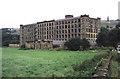
Titanic Mill
This textile mill was built in 1912 and was hence known as Titanic Mill. It was lying derelict and unloved when I photographed it in 2002 but it has since been converted in to apartments and the photograph here Image was taken from practically the same location. In some ways I prefer the earlier photograph.
Image: © Chris Allen
Taken: 17 Aug 2002
0.08 miles