IMAGES TAKEN NEAR TO
Manchester Road, HUDDERSFIELD, HD7 5QH
Introduction
This page details the photographs taken nearby to Manchester Road, HD7 5QH by members of the Geograph project.
The Geograph project started in 2005 with the aim of publishing, organising and preserving representative images for every square kilometre of Great Britain, Ireland and the Isle of Man.

There are currently over 7.5m images from over14,400 individuals and you can help contribute to the project by visiting https://www.geograph.org.uk
Image Map
Images are licensed for reuse under creativecommons.org/licenses/by-sa/2.0
Notes
- Clicking on the map will re-center to the selected point.
- The higher the marker number, the further away the image location is from the centre of the postcode.
Image Listing (84 Images Found)
Images are licensed for reuse under creativecommons.org/licenses/by-sa/2.0
Image
Details
Distance
1
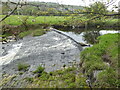
Weir on the River Colne
This supplied the mill pond for Westwood Mill that contained a water turbine. The mill is now a ruinous mess despite being Listed and the mill pond contains a small juvenile wood.
Image: © Chris Allen
Taken: 4 May 2023
0.04 miles
2
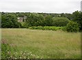
Field next to the River Colne, Low Westwood, Golcar
As part of a mission to find the viewpoint of an old photograph, I crossed the bed of the old millpond for Westwood Mills and climbed the bank at the far side. I found a narrow hayfield between the bank and the river. The view of Linthwaite is restricted by trees, and only two rows of houses are visible, possibly Coldwell Street.
Image: © Humphrey Bolton
Taken: 12 Jul 2007
0.05 miles
3
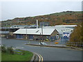
Works, Linthwaite
Manufacturers of healthcare products.
Image: © JThomas
Taken: 8 Nov 2018
0.07 miles
4
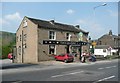
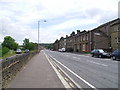
The Coach and Horses, Manchester Road A62, Linthwaite
The name dating from the turnpike era, one of many public houses built after the new Manchester Road was constructed c.1821.
Image: © Humphrey Bolton
Taken: 8 May 2008
0.07 miles
6
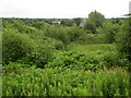
Disused millpond near Low Westwood, Golcar
The vegetation in the foreground is on the bed of the millpond (for Westwood Mill), which was contained between the retaining wall for the canal towpath and an embankment, beyond which a narrow field slopes down to the River Colne. In the distance the square tower of the mill in Linthwaite can just be seen, a little below the horizon and slightly left of centre.
Image: © Humphrey Bolton
Taken: 12 Jul 2007
0.08 miles

8
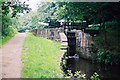
Lock No 18E, Huddersfield Narrow Canal
Looking west. The name of the lock is Can Lock.
Image: © Dr Neil Clifton
Taken: 7 Jul 2003
0.10 miles

10
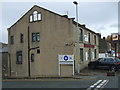
The Coach & Horses, Linthwaite
On Manchester Road (A62).
Image: © JThomas
Taken: 8 Nov 2018
0.11 miles