IMAGES TAKEN NEAR TO
Stones Lane, HUDDERSFIELD, HD7 5PP
Introduction
This page details the photographs taken nearby to Stones Lane, HD7 5PP by members of the Geograph project.
The Geograph project started in 2005 with the aim of publishing, organising and preserving representative images for every square kilometre of Great Britain, Ireland and the Isle of Man.

There are currently over 7.5m images from over14,400 individuals and you can help contribute to the project by visiting https://www.geograph.org.uk
Image Map
Images are licensed for reuse under creativecommons.org/licenses/by-sa/2.0
Notes
- Clicking on the map will re-center to the selected point.
- The higher the marker number, the further away the image location is from the centre of the postcode.
Image Listing (48 Images Found)
Images are licensed for reuse under creativecommons.org/licenses/by-sa/2.0
Image
Details
Distance
1
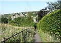
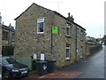
Buildings at Upper Clough, Linthwaite
The building on the left has small semi-circular windows, and might have been a barn.
Image: © Humphrey Bolton
Taken: 12 Jul 2007
0.05 miles
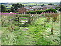
2
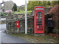
Road junction at Upper Clough, Linthwaite
Here there is a little triangular island on a steep slope, with telephone box (with its own telephone pole), postbox (Victorian), bus stop, street light and water trough. High House Lane goes steeply up to the right, and Upper Clough Road to the left.
Image: © Humphrey Bolton
Taken: 12 Jul 2007
0.05 miles
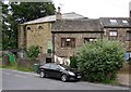
3
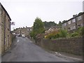
Upper Clough Road, Linthwaite
This road is part of the route from the A62 to Blackmoorfoot, which climbs over 100m in 1300m, but is nowhere excessively steep.
Image: © Humphrey Bolton
Taken: 12 Jul 2007
0.05 miles
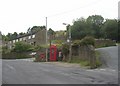
4
Victorian postbox and telephone box, Upper Clough
Postbox No. HD7 75.
See Image] for postbox.
Image: © JThomas
Taken: 8 Nov 2018
0.06 miles
5
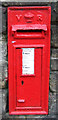
Victorian postbox, Upper Clough
Postbox No. HD7 75.
See Image] for wider view.
Image: © JThomas
Taken: 8 Nov 2018
0.06 miles
7
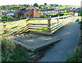
Colne Valley Sculpture Trail #2 (garden fence)
Text copied from http://www.mapfodder.com/sculptureTrail.pdf
"2: Angela Paradina - Impermanent Border (Mixed wooden fence panels)
Paradina's works both mock and question the concept of a border. In the first of two nearby pieces, she has used a random selection of found panels to create a clear border - yet has simultaneously subverted its implied permanence by its ramshackle and temporary appearance."
Image: © Humphrey Bolton
Taken: 1 Aug 2013
0.08 miles
8
Mysterious plinth at Flat House
The 1917 1:2500 map has the caption 'Tk.' at this location, presumably a tank, but what was it for?
Image: © Humphrey Bolton
Taken: 1 Aug 2013
0.08 miles