IMAGES TAKEN NEAR TO
Crofton Close, HUDDERSFIELD, HD7 5NH
Introduction
This page details the photographs taken nearby to Crofton Close, HD7 5NH by members of the Geograph project.
The Geograph project started in 2005 with the aim of publishing, organising and preserving representative images for every square kilometre of Great Britain, Ireland and the Isle of Man.

There are currently over 7.5m images from over14,400 individuals and you can help contribute to the project by visiting https://www.geograph.org.uk
Image Map
Images are licensed for reuse under creativecommons.org/licenses/by-sa/2.0
Notes
- Clicking on the map will re-center to the selected point.
- The higher the marker number, the further away the image location is from the centre of the postcode.
Image Listing (39 Images Found)
Images are licensed for reuse under creativecommons.org/licenses/by-sa/2.0
Image
Details
Distance


3
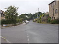
Waingate - looking up from Waingate Park
Image: © Betty Longbottom
Taken: 2 Aug 2016
0.06 miles


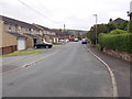
6

Electricity Substation No 321 - The Ridgeways
Image: © Betty Longbottom
Taken: 2 Aug 2016
0.08 miles
8
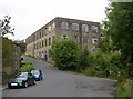
Mill building, Waingate, Linthwaite
Part of Lockwood's Black Rock Mills at Lower Clough.
Image: © Humphrey Bolton
Taken: 12 Jul 2007
0.10 miles
9

Lower Clough - viewed from Chapel Hill
Image: © Betty Longbottom
Taken: 2 Aug 2016
0.12 miles
