IMAGES TAKEN NEAR TO
Manchester Road, HUDDERSFIELD, HD7 5LS
Introduction
This page details the photographs taken nearby to Manchester Road, HD7 5LS by members of the Geograph project.
The Geograph project started in 2005 with the aim of publishing, organising and preserving representative images for every square kilometre of Great Britain, Ireland and the Isle of Man.

There are currently over 7.5m images from over14,400 individuals and you can help contribute to the project by visiting https://www.geograph.org.uk
Image Map
Images are licensed for reuse under creativecommons.org/licenses/by-sa/2.0
Notes
- Clicking on the map will re-center to the selected point.
- The higher the marker number, the further away the image location is from the centre of the postcode.
Image Listing (78 Images Found)
Images are licensed for reuse under creativecommons.org/licenses/by-sa/2.0
Image
Details
Distance
2
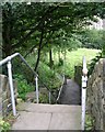
Footpath - Manchester Road, Linthwaite
Image: © Betty Longbottom
Taken: 8 Aug 2008
0.05 miles
4
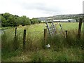
Unused kissing gate, Linthwaite
A mystery here; maps do not show a footpath along the side of the river. Perhaps it was intended that one be created, and the gate was delivered in anticipation but the idea fell through?
Image: © Humphrey Bolton
Taken: 16 Aug 2007
0.09 miles
5
Footpath - Manchester Road, Linthwaite
Image: © Betty Longbottom
Taken: 8 Aug 2008
0.09 miles
6
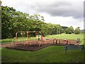
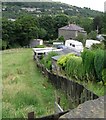
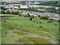
Slaithwaite Spa recreation ground, Linthwaite
A health spa opened here in 1825, with baths fed by sulphur and iron-rich water piped from springs by Richard Varley. By 1891 the Slaithwaite Spa & Hydropathic Establishment Ltd. had built new swimming baths across the river, whereas on this side there was a grand hall (approximately where the children's play area is now), bandstand, bowling green, tennis courts and gardens. A cinema had opened by 1914. The two sides of the river were connected by a wooden bridge, which was swept away by a flood c.1947. In the Second World War the park was requisitioned for the training of soldiers, and after the war the hall was demolished and the park neglected. It was not until 2004 that volunteers and Kirklees Council started to improve the park for recreation and wildlife. (Information from a board in the park)
Image: © Humphrey Bolton
Taken: 16 Aug 2007
0.09 miles
7
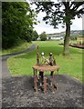
Sculpture in Slaithwaite Spa recreation ground, Linthwaite
Perhaps meant to be a reminder of mill machinery?
Image: © Humphrey Bolton
Taken: 16 Aug 2007
0.09 miles
8
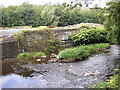
Storm Sewage Outfall, Spa, Slaithwaite
Most of the old sewers carry rainwater from roads and roofs as well as sewage. In the old days the sewage works for Slaithwaite was in what is now part of a highways depot, behind the outfall bay. For various reasons the treatment of sewage has been centralised, and in the mid-20C a sewer was laid down the valley to connect with the Huddersfield system at Milnsbridge. It is not affordable to install the enormous pipes that would be necessary to carry all the surface-water runoff down to the Huddersfield sewage works at Deighton, and in any case the works could not cope with the large flows that occur during rainfall. There is therefore an overflow at this point, and it was reconstructed using the latest vortex design when the inlet sewer had to be relaid at a lower level in order to allow the canal to be reopened. This was because a lock on the canal was to be relocated further upstream, and also a sewer pipe-bridge had been constructed across the canal around a metre above water level.
Image: © Humphrey Bolton
Taken: 16 Aug 2007
0.09 miles
10
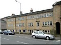
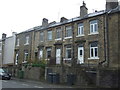
Spring Grove, Manchester Road A62, Linthwaite
Dated 1824, and with weaver's windows on the top floor, which was a workshop.
Image: © Humphrey Bolton
Taken: 3 Apr 2008
0.11 miles