IMAGES TAKEN NEAR TO
Nields Road, HUDDERSFIELD, HD7 5HT
Introduction
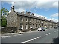
This page details the photographs taken nearby to Nields Road, HD7 5HT by members of the Geograph project.
The Geograph project started in 2005 with the aim of publishing, organising and preserving representative images for every square kilometre of Great Britain, Ireland and the Isle of Man.

There are currently over 7.5m images from over14,400 individuals and you can help contribute to the project by visiting https://www.geograph.org.uk
Image Map
Images are licensed for reuse under creativecommons.org/licenses/by-sa/2.0
Notes
- Clicking on the map will re-center to the selected point.
- The higher the marker number, the further away the image location is from the centre of the postcode.
Image Listing (115 Images Found)
Images are licensed for reuse under creativecommons.org/licenses/by-sa/2.0
Image
Details
Distance
1
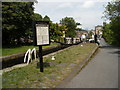
Slaithwaite's stone mills, viaduct and terraced housing
Viewed from Manchester Road
Image: © Raymond Knapman
Taken: 11 Apr 2014
0.02 miles
2
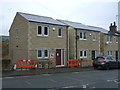
New houses on Manchester Road (A62), Slaithwaite
Faced in stone to match existing houses on the road.
Image: © JThomas
Taken: 8 Nov 2018
0.02 miles
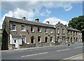
3
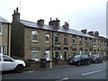
Terraced housing on Manchester Road (A62), Slaithwaite
Image: © JThomas
Taken: 8 Nov 2018
0.04 miles
4
Terrace houses, Manchester Road A62, Lingards (Slaithwaite)
Not all the same; the two on the left have different window and door lintels, and are narrower from front to back.
Image: © Humphrey Bolton
Taken: 19 Jun 2008
0.04 miles
5
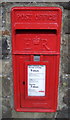
Elizabeth II postbox on Manchester Road (A62), Slaithwaite
Postbox No. HD7 196.
Image: © JThomas
Taken: 8 Nov 2018
0.05 miles
6
Wood Top, Manchester Road A62, Lingards (Slaithwaite)
This row of seven terrace houses has a projecting house in the centre, with the name 'Wood Top' and the date 1873.
Image: © Humphrey Bolton
Taken: 19 Jun 2008
0.05 miles
7
Slaithwaite, milepost
Iron milepost on Manchester Road (A62) with stone backing, of a pattern familiar in Yorkshire; the other facet gives distances to Huddersfield (5 Miles).
Image: © Mike Faherty
Taken: 17 Oct 2009
0.08 miles
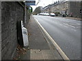
8
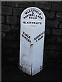
Old milestone
This West Riding CC milestone is on Manchester Road, Slaithwaite adjacent to a central refuge and near a bus stop. It had all the old paint stripped off in 2014 and then was repainted. It is another that is set with the metal attachment at full height with all four fixing points into the backing stone visible. There will be 20cm of stone below pavement level. It is Grade II listed 1275353.
Image: © Chris Minto
Taken: 5 Apr 2018
0.08 miles
9
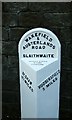
Old Milestone by the A62, Manchester Road, Slaithwaite
Metal plate attached to stone post by the A62, in parish of HUDDERSFIELD (KIRKLEES District), Manchester Road, Slaithwaite, adjacent to central refuge, near bus stop, on South side of road. Brayshaw & Booth iron casting, erected by the County Council in the 19th century.
Inscription reads:-
: OLDHAM / 12½ : : WAKEFIELD / & / AUSTERLANDS / ROAD / SLAITHWAITE : : HUDDERSFIELD / 5 MILES :
Maker:-
: BRAYSHAW & BOOTH / MAKERS / LIVERSEDGE :
Grade II listed. List Entry Number: 1275353
https://historicengland.org.uk/listing/the-list/list-entry/1275353
Milestone Society National ID: YW_HUOD05.
Image: © C Minto
Taken: 1 Oct 2001
0.09 miles