IMAGES TAKEN NEAR TO
Belmont Street, HUDDERSFIELD, HD7 5HJ
Introduction
This page details the photographs taken nearby to Belmont Street, HD7 5HJ by members of the Geograph project.
The Geograph project started in 2005 with the aim of publishing, organising and preserving representative images for every square kilometre of Great Britain, Ireland and the Isle of Man.

There are currently over 7.5m images from over14,400 individuals and you can help contribute to the project by visiting https://www.geograph.org.uk
Image Map
Images are licensed for reuse under creativecommons.org/licenses/by-sa/2.0
Notes
- Clicking on the map will re-center to the selected point.
- The higher the marker number, the further away the image location is from the centre of the postcode.
Image Listing (232 Images Found)
Images are licensed for reuse under creativecommons.org/licenses/by-sa/2.0
Image
Details
Distance
1
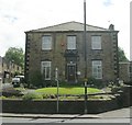
Croft House Surgery - Manchester Road, Slaithwaite
Image: © Betty Longbottom
Taken: 8 Aug 2008
0.01 miles
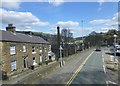
2
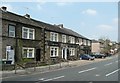
The Star, Manchester Road A62, Linthwaite
A long building; it looks as if the pub has extended into an adjoining house.
Image: © Humphrey Bolton
Taken: 8 May 2008
0.02 miles
3
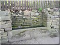
Trough, Manchester Road A62, Lingards (Slaithwaite)
A reminder that horse-drawn vehicles lasted well into the 20C.
Image: © Humphrey Bolton
Taken: 8 May 2008
0.02 miles
5
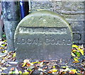
Local board boundary stone
This is over the stream that was the boundary between Lingards and Linthwaite townships.
Image: © Humphrey Bolton
Taken: 28 Oct 2013
0.04 miles
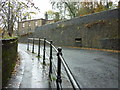
6
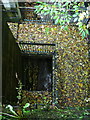
Subway under the A62
This was a surprise. I looked over the bridge parapet expecting to see only the stream.
Image: © Humphrey Bolton
Taken: 28 Oct 2013
0.04 miles
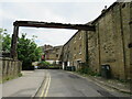
7
Sloping roof on terraced housing on Ned Lane
View from Manchester Road
Image: © Raymond Knapman
Taken: 11 Apr 2014
0.04 miles

9
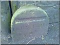
Old Boundary Marker by the A62, Manchester Road, Slaithwaite
Municipal Boundary Marker by the A62, in parish of Slaithwaite and Marsden (Kirklees District), Slaithwaite, immediately opposite Britannia Road junction, South side of road.
Surveyed
Milestone Society National ID: YW_SLAI04pb
Image: © Milestone Society
Taken: Unknown
0.05 miles
10
Kiln Hill, Slaithwaite
Kiln Hill in the village of Slaithwaite, in West Yorkshire.
Image: © Malc McDonald
Taken: 13 Jun 2021
0.05 miles