IMAGES TAKEN NEAR TO
Delves Gate, HUDDERSFIELD, HD7 5FA
Introduction
This page details the photographs taken nearby to Delves Gate, HD7 5FA by members of the Geograph project.
The Geograph project started in 2005 with the aim of publishing, organising and preserving representative images for every square kilometre of Great Britain, Ireland and the Isle of Man.

There are currently over 7.5m images from over14,400 individuals and you can help contribute to the project by visiting https://www.geograph.org.uk
Image Map
Images are licensed for reuse under creativecommons.org/licenses/by-sa/2.0
Notes
- Clicking on the map will re-center to the selected point.
- The higher the marker number, the further away the image location is from the centre of the postcode.
Image Listing (11 Images Found)
Images are licensed for reuse under creativecommons.org/licenses/by-sa/2.0
Image
Details
Distance
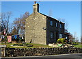
1
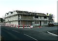
Building work at the Dyer?s Arms, Chain Road, Lingards
Image: © Humphrey Bolton
Taken: 5 Nov 2012
0.01 miles
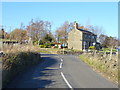
3
New build rounded building on the corner of the Blackmoor Foot Road in Holt Head
Image: © Chris
Taken: 12 Sep 2014
0.13 miles
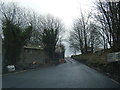
6
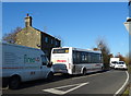
Rural traffic jam on the B6109, Holt Head
Difficult access for the Stotts local bus.
Image: © JThomas
Taken: 15 Nov 2018
0.17 miles
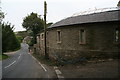
7
Bus stop and shelter on Chain Road, Holt Head
Image: © JThomas
Taken: 15 Nov 2018
0.17 miles
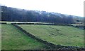
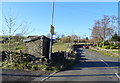
10
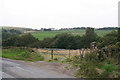
Gateway and path on the road from Holt Head to Blackmoor Foot
Image: © Chris
Taken: 12 Sep 2014
0.25 miles