IMAGES TAKEN NEAR TO
Mona Street, HUDDERSFIELD, HD7 5EJ
Introduction
This page details the photographs taken nearby to Mona Street, HD7 5EJ by members of the Geograph project.
The Geograph project started in 2005 with the aim of publishing, organising and preserving representative images for every square kilometre of Great Britain, Ireland and the Isle of Man.

There are currently over 7.5m images from over14,400 individuals and you can help contribute to the project by visiting https://www.geograph.org.uk
Image Map
Images are licensed for reuse under creativecommons.org/licenses/by-sa/2.0
Notes
- Clicking on the map will re-center to the selected point.
- The higher the marker number, the further away the image location is from the centre of the postcode.
Image Listing (201 Images Found)
Images are licensed for reuse under creativecommons.org/licenses/by-sa/2.0
Image
Details
Distance

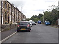
2

Recreation Ground - Meal Hill Lane
Image: © Betty Longbottom
Taken: 26 Jul 2016
0.04 miles

5
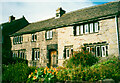
Aeneas and Elizabeth Bothomley's House, Hill Top, Slaithwaite
This is a yeoman farmer's house, dated 1685 on the lintel with the initials AB and EB.
Image: © Humphrey Bolton
Taken: 1 Oct 2000
0.06 miles


10
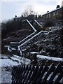
Steps to Royd Street, Slaithwaite
This seemingly endless set of steps rises steeply from outside the station to Royd Street.
Image: © Pamela Norrington
Taken: 2 Dec 2008
0.07 miles