IMAGES TAKEN NEAR TO
Bank Top, HUDDERSFIELD, HD7 5EF
Introduction
This page details the photographs taken nearby to Bank Top, HD7 5EF by members of the Geograph project.
The Geograph project started in 2005 with the aim of publishing, organising and preserving representative images for every square kilometre of Great Britain, Ireland and the Isle of Man.

There are currently over 7.5m images from over14,400 individuals and you can help contribute to the project by visiting https://www.geograph.org.uk
Image Map
Images are licensed for reuse under creativecommons.org/licenses/by-sa/2.0
Notes
- Clicking on the map will re-center to the selected point.
- The higher the marker number, the further away the image location is from the centre of the postcode.
Image Listing (259 Images Found)
Images are licensed for reuse under creativecommons.org/licenses/by-sa/2.0
Image
Details
Distance
1
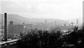
Slaithwaite: view up Colne Valley, 1960
'Dark, satanic mills'? SW view from a train on the Leeds - Huddersfield - Manchester main line.
Image: © Ben Brooksbank
Taken: 11 Apr 1960
0.01 miles

3
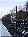
Slaithwaite Railway Station
East bound platform of Slaithwaite station.
Image: © Pamela Norrington
Taken: 2 Dec 2008
0.01 miles
4
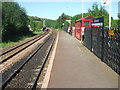
Slaithwaite railway station, Yorkshire
The original station was opened here in 1847 by the London & North Western Railway on the line from Huddersfield to Stalybridge, closing in 1968. It had four platforms and was later demolished.
The current station was opened in 1982. View north east towards Golcar and Huddersfield. The left hand (Huddersfield-bound) platform is on the site of the old station. This (Stalybridge-bound) platform is on the site of the old goods yard.
Image: © Nigel Thompson
Taken: 30 May 2009
0.02 miles


7
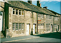
Cottages, Hill Top Road, Slaithwaite
Late 18C cottages with a date stone: WIH 1763.
Image: © Humphrey Bolton
Taken: 2 Nov 2020
0.03 miles
8

Royd Street - viewed from Meal Hill Lane
Image: © Betty Longbottom
Taken: 26 Jul 2016
0.03 miles
9
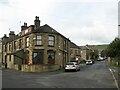
House at the corner of Meal Hill Lane & Royd Street
Formerly a shop. There is an inscription above the corner window which reads "White Royd Terrace 1890".
Image: © Stephen Armstrong
Taken: 10 Oct 2015
0.03 miles
