IMAGES TAKEN NEAR TO
Grove Street, HUDDERSFIELD, HD7 5DZ
Introduction
This page details the photographs taken nearby to Grove Street, HD7 5DZ by members of the Geograph project.
The Geograph project started in 2005 with the aim of publishing, organising and preserving representative images for every square kilometre of Great Britain, Ireland and the Isle of Man.

There are currently over 7.5m images from over14,400 individuals and you can help contribute to the project by visiting https://www.geograph.org.uk
Image Map
Images are licensed for reuse under creativecommons.org/licenses/by-sa/2.0
Notes
- Clicking on the map will re-center to the selected point.
- The higher the marker number, the further away the image location is from the centre of the postcode.
Image Listing (232 Images Found)
Images are licensed for reuse under creativecommons.org/licenses/by-sa/2.0
Image
Details
Distance


3

Union Street - looking towards Royd Street
Image: © Betty Longbottom
Taken: 26 Jul 2016
0.03 miles

5
Wood Street - looking towards Royd Street
Image: © Betty Longbottom
Taken: 26 Jul 2016
0.05 miles


8
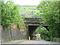
Bank Gate, Slaithwaite
Bank Gate in the village of Slaithwaite in West Yorkshire. Here the road passes beneath the main railway between Leeds and Manchester. Bank Gate is on the route of the Pennine Cycleway, National Cycle Network route 68.
Image: © Malc McDonald
Taken: 13 Jun 2021
0.07 miles
9

Royd Street - viewed from Meal Hill Lane
Image: © Betty Longbottom
Taken: 26 Jul 2016
0.07 miles