IMAGES TAKEN NEAR TO
Clay Lane, HUDDERSFIELD, HD7 5BG
Introduction
This page details the photographs taken nearby to Clay Lane, HD7 5BG by members of the Geograph project.
The Geograph project started in 2005 with the aim of publishing, organising and preserving representative images for every square kilometre of Great Britain, Ireland and the Isle of Man.

There are currently over 7.5m images from over14,400 individuals and you can help contribute to the project by visiting https://www.geograph.org.uk
Image Map
Images are licensed for reuse under creativecommons.org/licenses/by-sa/2.0
Notes
- Clicking on the map will re-center to the selected point.
- The higher the marker number, the further away the image location is from the centre of the postcode.
Image Listing (122 Images Found)
Images are licensed for reuse under creativecommons.org/licenses/by-sa/2.0
Image
Details
Distance


6
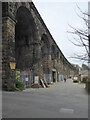
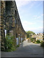
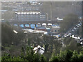
Crimble viaduct
Built in two halves c1845 and c1890 with 19 arches. Grade II Listed.
Image: © Chris Allen
Taken: 4 May 2023
0.05 miles
9
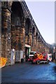
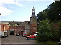
Small Businesses in the Viaduct Arches
Image: © Anthony Parkes
Taken: 21 Dec 2013
0.06 miles