IMAGES TAKEN NEAR TO
Ashford Park, HUDDERSFIELD, HD7 4RL
Introduction
This page details the photographs taken nearby to Ashford Park, HD7 4RL by members of the Geograph project.
The Geograph project started in 2005 with the aim of publishing, organising and preserving representative images for every square kilometre of Great Britain, Ireland and the Isle of Man.

There are currently over 7.5m images from over14,400 individuals and you can help contribute to the project by visiting https://www.geograph.org.uk
Image Map
Images are licensed for reuse under creativecommons.org/licenses/by-sa/2.0
Notes
- Clicking on the map will re-center to the selected point.
- The higher the marker number, the further away the image location is from the centre of the postcode.
Image Listing (62 Images Found)
Images are licensed for reuse under creativecommons.org/licenses/by-sa/2.0
Image
Details
Distance
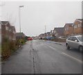
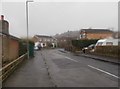
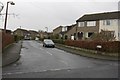
2
Spring Side Rise - Bankside
On a rainy day!
Image: © Betty Longbottom
Taken: 22 Dec 2015
0.07 miles
3
Spring Side Rise, Golcar
An attractive name, deriving from nearby springs in the hillside
Image: © Richard Kay
Taken: 24 Nov 2009
0.08 miles
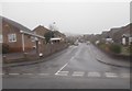
4
Bankside, Golcar
Perhaps named after the hillside to the north
Image: © Richard Kay
Taken: 24 Nov 2009
0.09 miles
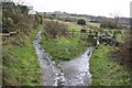
6
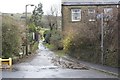
Hollin Hall Lane, Golcar
A bridleway leading up the hill to Hollin Hall
Image: © Richard Kay
Taken: 24 Nov 2009
0.11 miles
7
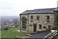
Room with a View, Hollin Hall
A converted barn with a superb view over Huddersfield. Emley Moor television mast Image is visible on the horizon.
Image: © Richard Kay
Taken: 24 Nov 2009
0.11 miles
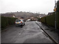
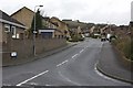
9
Banks Road, Golcar
Busier than expected on the day this was taken, since Leymoor Road was closed for roadworks.
Image: © Richard Kay
Taken: 24 Nov 2009
0.12 miles
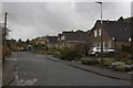
10
Hollin Hall Lane, Golcar
Hollin Hall Lane bridleway goes up to the left , whilst the footpath to Mole's Head branches off to the right.
Image: © Richard Kay
Taken: 24 Nov 2009
0.12 miles