IMAGES TAKEN NEAR TO
Clough Road, HUDDERSFIELD, HD7 4NP
Introduction
This page details the photographs taken nearby to Clough Road, HD7 4NP by members of the Geograph project.
The Geograph project started in 2005 with the aim of publishing, organising and preserving representative images for every square kilometre of Great Britain, Ireland and the Isle of Man.

There are currently over 7.5m images from over14,400 individuals and you can help contribute to the project by visiting https://www.geograph.org.uk
Image Map
Images are licensed for reuse under creativecommons.org/licenses/by-sa/2.0
Notes
- Clicking on the map will re-center to the selected point.
- The higher the marker number, the further away the image location is from the centre of the postcode.
Image Listing (23 Images Found)
Images are licensed for reuse under creativecommons.org/licenses/by-sa/2.0
Image
Details
Distance
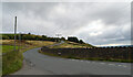
1
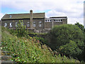
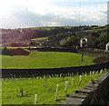
Clough Head
School building perched over Crimble Clough.
Image: © John Illingworth
Taken: 11 Jul 2007
0.03 miles
3
The entrance to Golcar Service Reservoir, Pinfold Lane, Clough Head
Image: © habiloid
Taken: 29 Aug 2022
0.09 miles
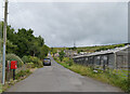
4
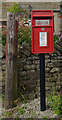
Post box, Pinfold Lane, Clough Head
This post box can be seen in context in Image
Image: © habiloid
Taken: 29 Aug 2022
0.09 miles
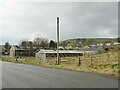
6
Pinfold Lane, Clough Head
A close-up of the post box can be seen in Image
Image: © habiloid
Taken: 29 Aug 2022
0.11 miles
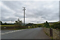
7
Redundant poultry sheds
By Slaithwaite Gate at Clough Head
Image: © Kevin Waterhouse
Taken: 25 Feb 2024
0.12 miles
9
Grazing and covered reservoir
Off Slaithwaite Gate.
Image: © JThomas
Taken: 2 Nov 2018
0.12 miles
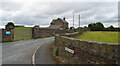
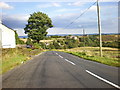
10
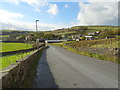
Slaithwaite Gate towards Clough Head
Looking west down the hill.
Image: © JThomas
Taken: 2 Nov 2018
0.14 miles