IMAGES TAKEN NEAR TO
Nettleton Hill Road, HUDDERSFIELD, HD7 4NH
Introduction
This page details the photographs taken nearby to Nettleton Hill Road, HD7 4NH by members of the Geograph project.
The Geograph project started in 2005 with the aim of publishing, organising and preserving representative images for every square kilometre of Great Britain, Ireland and the Isle of Man.

There are currently over 7.5m images from over14,400 individuals and you can help contribute to the project by visiting https://www.geograph.org.uk
Image Map
Images are licensed for reuse under creativecommons.org/licenses/by-sa/2.0
Notes
- Clicking on the map will re-center to the selected point.
- The higher the marker number, the further away the image location is from the centre of the postcode.
Image Listing (59 Images Found)
Images are licensed for reuse under creativecommons.org/licenses/by-sa/2.0
Image
Details
Distance
1
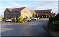
Pennine Manor Hotel - Nettleton Hill Road
Image: © Betty Longbottom
Taken: 8 Dec 2015
0.01 miles
2
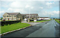
Pennine Manor Hotel, Nettleton Hill Road, Longwood
This is on the site of Hall Edge Farm.
Image: © Humphrey Bolton
Taken: 16 May 2022
0.02 miles

5
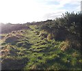
Longwood Common, near Green Edge
On the public footpath across Longwood Common. The outskirts of Calderdale can be viewed in the distance.
Image: © Samantha Waddington
Taken: 2 Mar 2013
0.07 miles
6
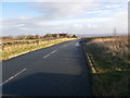
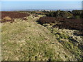
Nettleton Hill Road - Round Ings Road
Image: © Betty Longbottom
Taken: 8 Dec 2015
0.10 miles
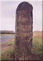
7
![Milestone [from the east], Longwood Common](https://s1.geograph.org.uk/geophotos/04/45/08/4450817_8c0742d3_120x120.jpg)
Milestone [from the east], Longwood Common
Mostly illegible, but gives the distance to two places. One is clearly Halifax, 4 miles. Halifax Road starts at this road junction.
Image: © Christine Johnstone
Taken: 19 Apr 2015
0.10 miles
8
![Milestone [from the west], Longwood Common](https://s2.geograph.org.uk/geophotos/04/45/08/4450810_b94c782b_120x120.jpg)
Milestone [from the west], Longwood Common
Inscribed on this side 'Mr John Haigh and Abraham Hall Snr 1756'. Presumably they paid for it.
Image: © Christine Johnstone
Taken: 19 Apr 2015
0.10 miles
9
Old Milestone, Scapegoat Hill
The milestone is located at the junction of Roundings Road, Nettleton Hill, and School Lane. Parish of Colne Valley. Carved stone post, erected in the 18th century by the parish.
Inscription reads:- Mr John/Haigh and/Abraham/Hall Sn(r)/1756 : : To {arrow to left} /Rippon(d)/3 Mil(e)/Halfeax/4 Mile/ {arrow to left} /To Slaighwai(te)/2 Mile
Grade II Listed, number 1228187, https://historicengland.org.uk/listing/the-list/list-entry/1228187
Milestone ID: YW_XHUDd
Image: © Milestone Society
Taken: Unknown
0.11 miles
10
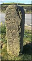
Old Milestone, Scapegoat Hill
The milestone is located at the junction of Roundings Road, Nettleton Hill, and School Lane. Parish of Colne Valley. Carved stone post, erected in the 18th century by the parish.
Inscription reads:- Mr John/Haigh and/Abraham/Hall Sn(r)/1756 :: To {arrow to left} /Rippon(d)/3 Mil(e)/Halfeax/4 Mile/ {arrow to left} /To Slaighwai(te)/2 Mile
Grade II Listed, List Entry Number 1228187, https://historicengland.org.uk/listing/the-list/list-entry/1228187
Milestone ID: YW_XHUDd
Image: © David Garside
Taken: 12 Apr 2021
0.11 miles