IMAGES TAKEN NEAR TO
Victoria Lane, HUDDERSFIELD, HD7 4JG
Introduction
This page details the photographs taken nearby to Victoria Lane, HD7 4JG by members of the Geograph project.
The Geograph project started in 2005 with the aim of publishing, organising and preserving representative images for every square kilometre of Great Britain, Ireland and the Isle of Man.

There are currently over 7.5m images from over14,400 individuals and you can help contribute to the project by visiting https://www.geograph.org.uk
Image Map
Images are licensed for reuse under creativecommons.org/licenses/by-sa/2.0
Notes
- Clicking on the map will re-center to the selected point.
- The higher the marker number, the further away the image location is from the centre of the postcode.
Image Listing (114 Images Found)
Images are licensed for reuse under creativecommons.org/licenses/by-sa/2.0
Image
Details
Distance
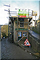
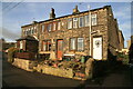
1
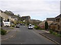
Fullwood Drive, Golcar
This residential road is off Victoria Lane. What caught the eye was the large building in the distance; I have taken two close-up photographs of it, qv.
Image: © Humphrey Bolton
Taken: 19 Apr 2007
0.03 miles
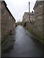
2
Cliffe Ash - Church Street, Golcar
Image: © Betty Longbottom
Taken: 13 Aug 2008
0.03 miles
3
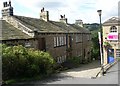
Golcar hillside
South-west of Town End. Golcar rhymes with joker.
Image: © Christine Johnstone
Taken: 19 Apr 2015
0.03 miles
4
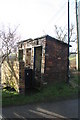
Comfort stations
Three disused outdoor water closets. Despite the usual association with brick outhouses, these don't look particularly robust. They also appear more modern than the adjoining stone weavers' cottages.
Image: © Chris Allen
Taken: 11 Dec 2010
0.05 miles
5
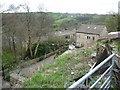
Colne Valley Museum, Golcar
A little local museum in former weavers' cottages. This end elevation use to contain a fish and chips shop.
Image: © Chris Allen
Taken: 11 Dec 2010
0.05 miles
7
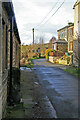
Ridings Lane, Golcar
The Colne Valley Museum is to the left and large piece of stone contains 'wuzzing holes'. See - Image Typical top floor windows of weavers' cottages are seen in the right background. Golcar was a stronghold of the domestic woollen industry but a few larger stone-built mills followed.
Image: © Chris Allen
Taken: 11 Dec 2010
0.05 miles
8
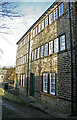
Colne Valley Museum, Golcar
The closely spaced windows on the first and second floors are indicative of a building used in the domestic woollen industry - weavers' cottages.
Image: © Chris Allen
Taken: 11 Dec 2010
0.06 miles
9
Former weavers' cottages Ridings Lane, Golcar
The closely spaced top floor windows are typical of weavers' cottages and hand looms would be housed on the top floor with the windows providing good natural light. Golcar has a large collection of such buildings and the Colne Valley Museum is housed in one such range.
Image: © Chris Allen
Taken: 11 Dec 2010
0.06 miles
10
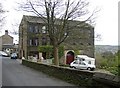
Building at Clay Well, Golcar (1)
This looks to be half way between a weaver's cottage and a woollen mill. The English Heritage listing gives it as “Nos 27 & 29 and adjoining factory building”, mid-19C. The factory part on the right has a carriage or cart entrance, and industrial-type windows to the upper floor, and unusual semi-circular windows to the first floor.
Image: © Humphrey Bolton
Taken: 19 Apr 2007
0.06 miles