IMAGES TAKEN NEAR TO
Chapel Terrace, HUDDERSFIELD, HD7 4HY
Introduction
This page details the photographs taken nearby to Chapel Terrace, HD7 4HY by members of the Geograph project.
The Geograph project started in 2005 with the aim of publishing, organising and preserving representative images for every square kilometre of Great Britain, Ireland and the Isle of Man.

There are currently over 7.5m images from over14,400 individuals and you can help contribute to the project by visiting https://www.geograph.org.uk
Image Map
Images are licensed for reuse under creativecommons.org/licenses/by-sa/2.0
Notes
- Clicking on the map will re-center to the selected point.
- The higher the marker number, the further away the image location is from the centre of the postcode.
Image Listing (109 Images Found)
Images are licensed for reuse under creativecommons.org/licenses/by-sa/2.0
Image
Details
Distance
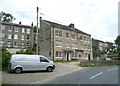
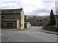
1
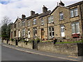
Top end of Station Road, Golcar
At the junction with James Street / Carr Top Lane. There were houses in the area of grass on the left.
Image: © Humphrey Bolton
Taken: 19 Apr 2007
0.03 miles
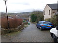
2
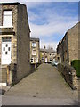
Back lane off Chapel Lane, Golcar
This connects Chapel Lane with Station Road.
Image: © Humphrey Bolton
Taken: 19 Apr 2007
0.03 miles
3
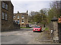
Ainley Street, Golcar
Taken from Station Road. The sign 'unadopted' below the street name-plate indicates that the council is not responsible for the repair of the road, to forestall complaints.
Image: © Humphrey Bolton
Taken: 19 Apr 2007
0.05 miles
4
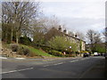
Terrace houses, Station Road, Golcar
The roof-line of terrace houses is quite often broken by gables without windows, ie as a feature rather than to provide light to the loft space. In this case the spacing of the gables does not relate to the spacing of the windows, whereas in other cases the gables often emphasise the central house of a block.
Image: © Humphrey Bolton
Taken: 19 Apr 2007
0.05 miles
5
The Wheel Inn, James Street, Golcar
From this angle the pub looks to be a building sliced in half, but in fact it is just chamfered off a little to follow the line of Park Lane East, behind the van and what must be a champion telephone pole with an enormous number of lines radiating from it.
Image: © Humphrey Bolton
Taken: 8 Jul 2008
0.05 miles
7
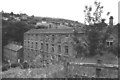
Albion Mills, Brook Lane, Golcar
Thanks to Humphrey Bolton I now know where my "mystery mill" is and can now post my own view (practically identical to his) taken nearly 24 years earlier.
There was a little scrapyard a few yards away with the remains of some sort of jet aircraft. Humphrey confirms that is all long gone. Let's hope they don't ruin the mill too much (one of my pet hates).
Image: © Chris Allen
Taken: 1 Jul 1983
0.09 miles
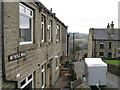
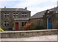
9
Carr Top Lane, Golcar
Carr Top Lane splits at the bottom end, with a house in the triangle so formed.
Image: © Humphrey Bolton
Taken: 19 Apr 2007
0.09 miles
10
Rear of Baptist chapel, Chapel Lane, Golcar
The building straight ahead was built as a Sunday school in 1896 and adapted for use as a chapel in the late 1960s.
Set into the wall is the datestone for a chapel of 1834, the first one.
The photograph is taken from what would have been the interior of another chapel, built 1867 when the church outgrew the 1834 building and demolished in the early 1970s. It is now a car park. The small wall in the foreground was part of the exterior wall of the 1867 chapel.
The building on the right is dated 1929 over the door. It is referred to as 'the covered way' and was built to provide a corridor between the 1867 chapel and the 1896 Sunday school, as well as to provide on-site indoor toilets.
Image: © Humphrey Bolton
Taken: 19 Apr 2007
0.09 miles