IMAGES TAKEN NEAR TO
Handel Street, HUDDERSFIELD, HD7 4AB
Introduction
This page details the photographs taken nearby to Handel Street, HD7 4AB by members of the Geograph project.
The Geograph project started in 2005 with the aim of publishing, organising and preserving representative images for every square kilometre of Great Britain, Ireland and the Isle of Man.

There are currently over 7.5m images from over14,400 individuals and you can help contribute to the project by visiting https://www.geograph.org.uk
Image Map
Images are licensed for reuse under creativecommons.org/licenses/by-sa/2.0
Notes
- Clicking on the map will re-center to the selected point.
- The higher the marker number, the further away the image location is from the centre of the postcode.
Image Listing (110 Images Found)
Images are licensed for reuse under creativecommons.org/licenses/by-sa/2.0
Image
Details
Distance
1
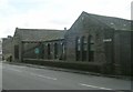
Knowl Bank Board Schools - Knowl Road, Golcar
Enlarged 1896.
Image: © Betty Longbottom
Taken: 13 Aug 2008
0.02 miles
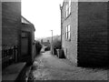
2
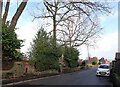
Knowl Road, Golcar
A close-up of the derelict post box can be seen in Image
Image: © habiloid
Taken: 21 Feb 2022
0.03 miles
4
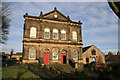
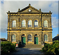
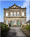
Golcar Providence Methodist Church
A solid and well kept building that is typical of its type.
Image: © Chris Allen
Taken: 11 Dec 2010
0.04 miles
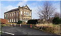
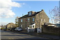
10
Golcar Central Working Men's Co-operative Society Ltd - James Street
Image: © Betty Longbottom
Taken: 13 Aug 2008
0.04 miles