IMAGES TAKEN NEAR TO
James Street, HUDDERSFIELD, HD7 4AA
Introduction
This page details the photographs taken nearby to James Street, HD7 4AA by members of the Geograph project.
The Geograph project started in 2005 with the aim of publishing, organising and preserving representative images for every square kilometre of Great Britain, Ireland and the Isle of Man.

There are currently over 7.5m images from over14,400 individuals and you can help contribute to the project by visiting https://www.geograph.org.uk
Image Map
Images are licensed for reuse under creativecommons.org/licenses/by-sa/2.0
Notes
- Clicking on the map will re-center to the selected point.
- The higher the marker number, the further away the image location is from the centre of the postcode.
Image Listing (99 Images Found)
Images are licensed for reuse under creativecommons.org/licenses/by-sa/2.0
Image
Details
Distance
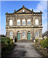
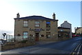
2
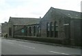
Former Co-op shop, James Street, Golcar
On the pediment: “1901 Central Men's Co-operative Society Ltd”.
Image: © Humphrey Bolton
Taken: 8 Jul 2008
0.01 miles
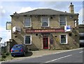
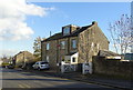
3
Golcar Central Working Men's Co-operative Society Ltd - James Street
Image: © Betty Longbottom
Taken: 13 Aug 2008
0.01 miles
4
Knowl Bank Board Schools - Knowl Road, Golcar
Enlarged 1896.
Image: © Betty Longbottom
Taken: 13 Aug 2008
0.03 miles
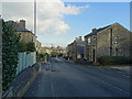
7
Scarhouse Lane - James Street, Golcar
Image: © Betty Longbottom
Taken: 13 Aug 2008
0.04 miles
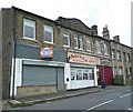
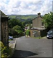
8
Junction One, Cafe Bar, Golcar
Junction of Knowl Road, James Street.
Image: © JThomas
Taken: 2 Nov 2018
0.05 miles
9
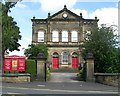
Golcar Providence Methodist Church - Knowl Road
Built 1883.
Image: © Betty Longbottom
Taken: 13 Aug 2008
0.05 miles