IMAGES TAKEN NEAR TO
Church Paddocks, BRIGHOUSE, HD6 4LD
Introduction
This page details the photographs taken nearby to Church Paddocks, HD6 4LD by members of the Geograph project.
The Geograph project started in 2005 with the aim of publishing, organising and preserving representative images for every square kilometre of Great Britain, Ireland and the Isle of Man.

There are currently over 7.5m images from over14,400 individuals and you can help contribute to the project by visiting https://www.geograph.org.uk
Image Map
Images are licensed for reuse under creativecommons.org/licenses/by-sa/2.0
Notes
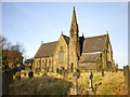
- Clicking on the map will re-center to the selected point.
- The higher the marker number, the further away the image location is from the centre of the postcode.
Image Listing (111 Images Found)
Images are licensed for reuse under creativecommons.org/licenses/by-sa/2.0
Image
Details
Distance
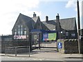
2
Former Co-op - Towngate, Clifton
After being a Co-op this became the Post Office, but has now been closed down.
Image: © Betty Longbottom
Taken: 14 May 2008
0.02 miles
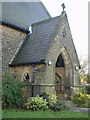
4
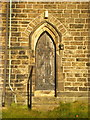
St John's Church, Clifton, Doorway
Image: © Alexander P Kapp
Taken: 15 Dec 2008
0.02 miles
5
Clifton Village Nursery - Towngate
Image: © Betty Longbottom
Taken: 20 Apr 2013
0.03 miles
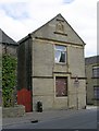
6
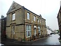
Former Shop, now a Dwellinghouse
This was formerly the Clifton Branch of the Brighouse Industrial Society, built in the year 1882.
Image: © Bill Henderson
Taken: 1 May 2014
0.03 miles
8
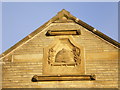
Detail on the gable end of the former Co-op building, Towngate, Clifton
Image: © Alexander P Kapp
Taken: 15 Dec 2008
0.03 miles
9
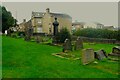
Gravestones in front of St John's Church, Clifton
The grass at the front of the church is neatly mown.
Image: © Humphrey Bolton
Taken: 11 Aug 2023
0.03 miles
10
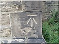
Ordnance Survey Cut Mark
This mark can be found on the wall of St John's Church in Clifton. The benchmark height has been calculated as being 127.437 metres above sea level.
For more detail see : https://www.bench-marks.org.uk/bm84099
Image: © Peter Wood
Taken: 25 Jul 2018
0.03 miles